Back مقاطعة هامبشاير (ماساتشوستس) Arabic Hampshire County, Massachusetts BAR Хампшър (окръг, Масачузетс) Bulgarian হেম্পশায়ার কাউন্টি, ম্যাসাচুসেট্স BPY Hampshire Gông (Massachusetts) CDO Хампшир (гуо, Массачусетс) CE Hampshire County (kondado sa Tinipong Bansa, Massachusetts) CEB Hampshire County, Massachusetts Welsh Hampshire County (Massachusetts) Danish Hampshire County (Massachusetts) German
Hampshire County | |
|---|---|
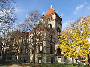
 Old Hampshire County Courthouse | |
 Location within the U.S. state of Massachusetts | |
 Massachusetts's location within the U.S. | |
| Coordinates: 42°20′N 72°40′W / 42.34°N 72.66°W | |
| Country | |
| State | |
| Founded | 1662 |
| Named for | Hampshire, England |
| Seat | Northampton |
| Largest town | Amherst |
| Area | |
| • Total | 545 sq mi (1,410 km2) |
| • Land | 527 sq mi (1,360 km2) |
| • Water | 18 sq mi (50 km2) 3.3% |
| Population (2020) | |
| • Total | 162,308 |
| • Density | 308.0/sq mi (118.9/km2) |
| Time zone | UTC−5 (Eastern) |
| • Summer (DST) | UTC−4 (EDT) |
| Congressional districts | 1st, 2nd |
Hampshire County is a historical and judicial county located in the U.S. state of Massachusetts. As of the 2020 census, the population was 162,308.[1] Its most populous municipality is Amherst (due to seasonal student population; the largest year-round is Northampton), its largest town in terms of landmass is Belchertown, and its traditional county seat is Northampton.[2] The county is named after the county Hampshire, in England.[3] Hampshire County is part of the Springfield, MA Metropolitan Statistical Area. Together with Hampden County, Hampshire County municipalities belong to the Pioneer Valley Planning Commission.[4]
- ^ "Census - Geography Profile: Hampshire County, Massachusetts". United States Census Bureau. Retrieved November 14, 2021.
- ^ "Find a County". National Association of Counties. Retrieved June 7, 2011.
- ^ Gannett, Henry (1905). The Origin of Certain Place Names in the United States. Govt. Print. Off. pp. 148.
- ^ Kinney, Jim (April 17, 2019). "Hampshire Council of Governments plans to cease operations; hopes to sell historic Northampton courthouse". The Republican. masslive. Retrieved July 16, 2020.
© MMXXIII Rich X Search. We shall prevail. All rights reserved. Rich X Search
