Back Hanga Roa Afrikaans هانجا روا Arabic Hanga Roa AST Ханга-Роа Byelorussian Ханга-Роа BE-X-OLD Ханга Роа Bulgarian Hanga Roa BS Hanga Roa Catalan Hanga Roa CEB Hanga Roa Czech
Hanga Roa | |
|---|---|
 Harbour in Hanga Roa | |
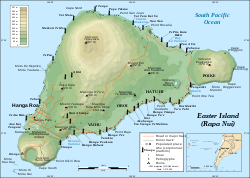
 Easter Island, map showing Hanga Roa, Terevaka, Rano Kau, and Mataveri International Airport, as well as the main tourist attractions Orongo, Rano Raraku, Ahu Tongariki and Anakena. | |
Location in the Pacific Ocean | |
| Coordinates: 27°08′S 109°25′W / 27.133°S 109.417°W | |
| Country | |
| Region | |
| Province | |
| Commune | |
| Founded | 9 September 1888 |
| Population | 7,322 |
| Time zone | UTC−06:00 |
| • Summer (DST) | UTC−05:00 |
| Climate | Af |
 | |
Hanga Roa (Spanish pronunciation: [ˈ(x)aŋɡa ˈro.a]; Rapa Nui: Haŋa Roa, Rapa Nui pronunciation: [ˈha.ŋa ˈɾo.a]) (Spanish: Bahía Larga) is the main town, harbour and seat of Easter Island, a municipality of Chile.[1] It is located in the southern part of the island's west coast, in the lowlands between the extinct volcanoes of Terevaka and Rano Kau.
© MMXXIII Rich X Search. We shall prevail. All rights reserved. Rich X Search
