Back نهر الحاصباني Arabic نهر الحاصبانى ARZ Hasbani Czech Эль-Хасбани CV Hasbani German Hasbani Esperanto Río Hasbani Spanish رودخانه حاصبانی Persian Hasbani French נחל שניר HE
| Hasbani River | |
|---|---|
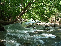
 Hazbani river in northern Israel | |
| Physical characteristics | |
| Source | Wazzani in Lebanon |
| • coordinates | 33°14′17″N 35°37′29″E / 33.23806°N 35.62472°E |
| 2nd source | Haqzbieh |
| Mouth | Jordan River |
• location | Sde Nehemia kibbutz in northern Israel |
• coordinates | 33°11′15″N 35°37′10″E / 33.18750°N 35.61944°E |
The Hasbani (Arabic: الحاصباني / ALA-LC: al-Ḥāṣbānī; Hebrew: חצבני Ḥatzbaní) or Snir Stream (Hebrew: נחל שניר / Nahal Sənir), is the major tributary of the Jordan River. Native people in the mid-19th century knew the Hasbani as the Upper Jordan River.[1]
The Hasbani River derives most of its discharge from two springs in Lebanon,[2][3] the Wazzani and the Haqzbieh, the latter being a group of springs on the uppermost Hasbani.[4] The Hasbani runs for 25 mi (40 km) through the Wadi al-Taym in Lebanon before crossing the border at Ghajar and shortly after joining with the Banias and Dan Rivers at a point in northern Israel, to form the River Jordan.[5] For about 4 km (2.5 mi) downstream of Ghajar, the Hasbani forms the border between Lebanon and the Golan Heights.
The Wazzani's and the Haqzbieh's combined discharge averages 138 million m³ per year.[6] About 20% of the Hasbani flow[7] emerges from the Wazzani Spring at Ghajar, close to the Lebanese-Golan Heights border, about 3 km (1.9 mi) west of the base of Mount Hermon. The contribution of the Wazzani spring is very important, since this is the only continuous year-round flow into the Hasbani, in either Lebanon or Israel.[8]
- ^ Velde, van de, C.W.M. (1854). Narrative of a journey through Syria and Palestine in 1851 and 1852. Vol. 1. William Blackwood and son. p. 168.
- ^ FAO (Water Resources section) "AQUASTAT - FAO's Information System on Water and Agriculture". Archived from the original on 2008-04-09. Retrieved 2011-04-26. "Overall, there are about 40 major streams in Lebanon and, based on the hydrographic system, the country can be divided into five regions: ... [including] the Hasbani river basin in the south-east."
- ^ UNU The Jordan River [1] Archived 2010-12-02 at the Wayback Machine "The Dan spring, the largest of the sources of the upper Jordan, lies wholly within Israel close to the border with Syria. The spring sources of the Hasbani River lie entirely within Lebanon. The spring source of the Banias River is in Syria. These three small streams unite 6 km inside Israel at about 70 m above sea level to form the upper Jordan River."
- ^ UNU The Jordan River [2] Archived 2010-12-02 at the Wayback Machine
- ^ MERIP Heightened Israeli-Lebanese Tensions Over Jordan's Headwaters [3] Archived 2016-12-29 at the Wayback Machine
- ^ "Managing water for peace in the Middle East". Archived from the original on 2010-12-02. Retrieved 2008-11-02.
- ^ Lebanon (FAOWater Resources section)"AQUASTAT - FAO's Information System on Water and Agriculture". Archived from the original on 2008-04-09. Retrieved 2011-04-26. "Lebanon being at a higher elevation than its neighbours has practically no incoming surface water flow…. Surface water flow to Israel is estimated at 160 million m³/year, of which about 138 million m³ through the Hasbani river including a contribution of 30 million m³ from its tributary, the Wazzani spring."
- ^ MERIP Heightened Israeli-Lebanese Tensions Over Jordan's Headwaters [4] Archived 2016-12-29 at the Wayback Machine "In the hot summer months, the Wazzani springs are the only source of flowing water in the Hasbani. Upstream from the Wazzani, the river is dry."
© MMXXIII Rich X Search. We shall prevail. All rights reserved. Rich X Search