Back Hauraki District CEB Hauraki District German District de Hauraki French Distretto di Hauraki Italian Daerah Hauraki Malay Hauraki District NN ضلع ہوراکی PNB Hauraki Destrict SCO
Hauraki District | |
|---|---|
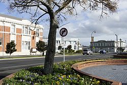
 Normanby Road, Paeroa, with the former Paeroa Post Office building at left | |
 | |
| Coordinates: 37°22′S 175°37′E / 37.37°S 175.62°E | |
| Country | New Zealand |
| Region | Waikato Region |
| Wards | Paeroa Plains Waihi |
| Seat | Paeroa |
| Government | |
| • Mayor | Toby Adams |
| • Territorial authority | Hauraki District Council |
| Area | |
| • Land | 1,270.12 km2 (490.40 sq mi) |
| Population (June 2023)[2] | |
| • Total | 22,400 |
| Time zone | UTC+12 (NZST) |
| • Summer (DST) | UTC+13 (NZDT) |
| Postcode(s) | |
| Website | Hauraki District Council |
Hauraki District is a territorial authority governed by the Hauraki District Council within the Hauraki region of New Zealand. The seat of the council is at Paeroa.
The area covered by the district extends from the southwest coast of the Firth of Thames southeast towards Te Aroha, although that town lies beyond its boundaries. It extends eastwards to the Bay of Plenty coast, taking in the southernmost part of the Coromandel Peninsula. The rest of the peninsula is part of Thames-Coromandel District.
Features of the district include the Karangahake Gorge, Whiritoa, the Hauraki Plains, Ngatea and the gold mining town of Waihi.
- ^ Cite error: The named reference
Areawas invoked but never defined (see the help page). - ^ "Subnational population estimates (RC, SA2), by age and sex, at 30 June 1996-2023 (2023 boundaries)". Statistics New Zealand. Retrieved 25 October 2023. (regional councils); "Subnational population estimates (TA, SA2), by age and sex, at 30 June 1996-2023 (2023 boundaries)". Statistics New Zealand. Retrieved 25 October 2023. (territorial authorities); "Subnational population estimates (urban rural), by age and sex, at 30 June 1996-2023 (2023 boundaries)". Statistics New Zealand. Retrieved 25 October 2023. (urban areas)
© MMXXIII Rich X Search. We shall prevail. All rights reserved. Rich X Search