Back هاوثورن Arabic هاوثورن ARZ هاوتورن، نوادا AZB Hawthorne Catalan Hawthorne (kapital sa kondado) CEB Hawthorne (Nevada) Czech Hawthorne (Nevada) German Hawthorne (Nevada) Spanish هاوثورن، نوادا Persian Hawthorne (Nevada) French
Hawthorne, Nevada | |
|---|---|
 E Street (U.S. Route 95) in downtown Hawthorne | |
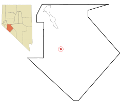
 Location in Mineral County and the state of Nevada | |
| Coordinates: 38°31′31″N 118°37′23″W / 38.52528°N 118.62306°W | |
| Country | United States |
| State | Nevada |
| County | Mineral |
| Founded | 1880 |
| Named for | William Hawthorne |
| Area | |
| • Total | 1.76 sq mi (4.56 km2) |
| • Land | 1.76 sq mi (4.56 km2) |
| • Water | 0.00 sq mi (0.00 km2) |
| Elevation | 4,331 ft (1,320 m) |
| Population | |
| • Total | 3,118 |
| • Density | 1,772.60/sq mi (684.39/km2) |
| Time zone | UTC−8 (PST) |
| • Summer (DST) | UTC−7 (PDT) |
| ZIP code | 89415 |
| Area code | 775 |
| FIPS code | 32-31300 |
| GNIS feature ID | 0848558 |
| Reference no. | 60 |
Hawthorne is an unincorporated community and census-designated place (CDP) in Mineral County, Nevada, United States. As of the 2020 census, the population was 3,118.[2] It is the county seat of Mineral County.[3] The nearby Hawthorne Army Depot is the primary economic base of the town.
- ^ "2023 U.S. Gazetteer Files: Nebraska". United States Census Bureau. Retrieved June 21, 2024.
- ^ a b "P1. Race – Hawthorne CDP, Nebraska: 2020 DEC Redistricting Data (PL 94-171)". U.S. Census Bureau. Retrieved June 21, 2024.
- ^ "Find a County". National Association of Counties. Retrieved June 7, 2011.
© MMXXIII Rich X Search. We shall prevail. All rights reserved. Rich X Search
