Back مقاطعة هينديرسون (كنتاكي) Arabic Henderson County, Kentucky BAR Хендерсън (окръг, Кентъки) Bulgarian হেন্ডারসন কাউন্টি, কেন্টাকি BPY Henderson Gông (Kentucky) CDO Хендерсон (гуо, Кентукки) CE Henderson County (kondado sa Tinipong Bansa, Kentucky) CEB Henderson County, Kentucky Welsh Henderson County (Kentucky) German Κομητεία Χέντερσον (Κεντάκι) Greek
Henderson County | |
|---|---|
 Henderson County courthouse in Henderson, Kentucky | |
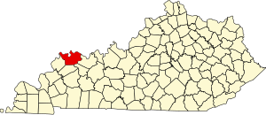
 Location within the U.S. state of Kentucky | |
 Kentucky's location within the U.S. | |
| Coordinates: 37°48′N 87°34′W / 37.8°N 87.57°W | |
| Country | |
| State | |
| Founded | 1798 |
| Named for | Richard Henderson |
| Seat | Henderson |
| Largest city | Henderson |
| Area | |
| • Total | 466 sq mi (1,210 km2) |
| • Land | 437 sq mi (1,130 km2) |
| • Water | 30 sq mi (80 km2) 6.4% |
| Population (2020) | |
| • Total | 44,793 |
| • Estimate (2023) | 44,119 |
| • Density | 96/sq mi (37/km2) |
| Time zone | UTC−6 (Central) |
| • Summer (DST) | UTC−5 (CDT) |
| Congressional district | 1st |
| Website | hendersonky |
Henderson County is a county in the U.S. state of Kentucky.
© MMXXIII Rich X Search. We shall prevail. All rights reserved. Rich X Search