| Holyoke Range | |
|---|---|
| Metacomet Ridge | |
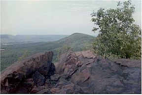
 View from Bare Mountain to Mount Norwottuck | |
| Highest point | |
| Peak | Mount Norwottuck |
| Elevation | 1,106 ft (337 m) |
| Coordinates | 42°18′20″N 72°30′36″W / 42.30556°N 72.51000°W |
| Dimensions | |
| Length | 9.5 mi (15.3 km) east-west |
| Geography | |
| Country | United States |
| State | Massachusetts |
| Range coordinates | 42°18′15″N 72°32′20″W / 42.30417°N 72.53889°W |
| Geology | |
| Age of rock | Triassic and Jurassic |
| Type of rock | fault-block, igneous and sedimentary |
The Holyoke Range or Mount Holyoke Range is a traprock mountain range located in the Connecticut River Valley of Massachusetts. It is a subrange of the narrow, linear Metacomet Ridge that extends from Long Island Sound near New Haven, Connecticut, north through the Connecticut River Valley of Massachusetts to the Vermont border. It is also a subrange of the Appalachian Mountains. A popular hiking destination, the range is known for its anomalous east–west orientation, high ledges and its scenic character. It is also notable for its unique microclimate ecosystems and rare plant communities, as well as significant historic sites, such as the Mount Holyoke Summit House and the Horse Caves.[1][2]
- ^ Farnsworth, Elizabeth J. "Metacomet-Mattabesett Trail Natural Resource Assessment." Archived 2007-08-07 at the Wayback Machine (2004). PDF file. Retrieved November 20, 2007.
- ^ Massachusetts DCR Retrieved December 10, 2007
© MMXXIII Rich X Search. We shall prevail. All rights reserved. Rich X Search
