Back هوج Arabic هوج ARZ Huj Danish Huj French הוג' HE Huj, Gaza ID Hudż Polish Huj, Gazze Turkish ہوج، غزہ Urdu
Huj
هوج al-Hug, Hojj, Houg | |
|---|---|
 Huj in 1948 | |
| Etymology: Possibly named after the prophet Og[1] | |
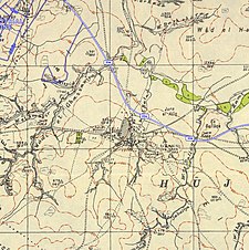
A series of historical maps of the area around Huj, Gaza (click the buttons) | |
Location within Mandatory Palestine | |
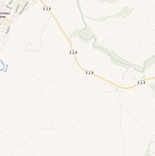
| Coordinates: 31°30′41″N 34°37′21″E / 31.51139°N 34.62250°E | |
| Palestine grid | 114/102 |
| Geopolitical entity | Mandatory Palestine |
| Subdistrict | Gaza |
| Date of depopulation | May 31, 1948[4] |
| Area | |
| • Total | 21,988 dunams (22.9 km2 or 8.8 sq mi) |
| Population (1945) | |
| • Total | 810[2][3] |
| Cause(s) of depopulation | Expulsion by Yishuv forces |
| Current Localities | Dorot[5] Havat Shikmim |
Huj (Arabic: هوج) was a Palestinian Arab village located 15 kilometers (9.3 mi) northeast of Gaza City. Identified as the site of the ancient Philistine town of Oga,[6] the modern village was founded by the Ottomans in the early 19th century.
Situated in a hilly area on the northern edge of the Negev Desert, it was depopulated during the 1948 Arab-Israeli War.
- ^ Palmer, 1881, p. 367,377
- ^ Department of Statistics, 1945, p. 31
- ^ Government of Palestine, Department of Statistics. Village Statistics, April, 1945. Quoted in Hadawi, 1970, p. 45
- ^ Morris, 2004, p. XX, village #366. Also gives cause of depopulation.
- ^ Khalidi, 1992, p. 103
- ^ Oga - (Huj) Studium Biblicum Franciscanum - Jerusalem. 2000-12-19.
© MMXXIII Rich X Search. We shall prevail. All rights reserved. Rich X Search


