Back Eiskeil German Cuña de hielo Spanish Coin de glace French טריז קרח HE Cuneo di ghiaccio Italian IJswig Dutch Iskiler NB Klin lodowy Polish Iskil Swedish


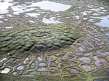
An ice wedge is a crack in the ground formed by a narrow or thin piece of ice that measures up to 3–4 meters in length at ground level and extends downwards into the ground up to several meters. During the winter months, the water in the ground freezes and expands. Once temperatures reach −17 degrees Celsius or lower,[citation needed] the ice that has already formed acts like a solid and expands to form cracks in the surface known as ice wedges. As this process continues over many years ice wedges can grow, up to the size of a swimming pool.[citation needed] Ice wedges usually appear in a polygonal pattern known as ice wedge polygons. The cracks can also be filled with materials other than ice, especially sand, and are then called sand wedges.
© MMXXIII Rich X Search. We shall prevail. All rights reserved. Rich X Search