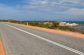
Indian Ocean Drive | |
|---|---|
 | |
| View south towards Leeman, 2014. | |
 | |
| General information | |
| Type | Highway |
| Length | 269 km (167 mi) |
| Opened | 2010 |
| Route number(s) | |
| Major junctions | |
| South end | |
| North end | |
| Location(s) | |
| Major settlements | Woodridge, Gabbadah, Lancelin, Cervantes, Jurien Bay, Green Head, Leeman |
| Highway system | |
| ---- | |
Indian Ocean Drive is a coastal highway in the Australian state of Western Australia which services the coastal communities along the Indian Ocean immediately north of the state capital Perth, linking the northern suburb of Yanchep with the Brand Highway, just south of Dongara. In terms of regions, most of it exists in the Wheatbelt coastal region. The road provides travellers between Perth and Geraldton a 30-minute shorter and more scenic route than the inland Brand Highway which mainly services heavy traffic.[1] The road also improved access to Wedge Island.
- ^ "Indian Ocean Drive". Main Roads WA. Archived from the original on 18 September 2010. Retrieved 16 September 2010.
© MMXXIII Rich X Search. We shall prevail. All rights reserved. Rich X Search
