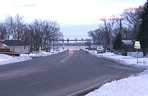
| Maple Street | ||||
SR 520 highlighted in red | ||||
| Route information | ||||
| Maintained by INDOT | ||||
| Length | 0.248 mi[1] (399 m) | |||
| Major junctions | ||||
| South end | ||||
| North end | ||||
| Location | ||||
| Country | United States | |||
| State | Indiana | |||
| Highway system | ||||
| ||||
| ||||

State Road 520 is a four-lane connector about 1,000 feet (300 m) in length. It exists solely to connect U.S. Route 12 and U.S. Route 20 in Pines, about 3 miles (4.8 km) west of Michigan City. U.S. 12 and U.S. 20 do not cross with each other — they parallel each other for another 22 miles (35 km) westbound and overlap in Gary; U.S. 20 is generally considered the faster of the two, while U.S. 12 is the scenic Dunes Highway. Eastbound, U.S. 12 travels through Michigan City and northeast into Michigan where it forks east from the Red Arrow Highway. U.S. 20 stays in Indiana and runs around Michigan City as a bypass to the south.
State Road 520 is the shortest designated highway in the State of Indiana.
- ^ Indiana Department of Transportation (July 2015). Reference Post Book (PDF). Indianapolis: Indiana Department of Transportation. Retrieved October 1, 2016.
© MMXXIII Rich X Search. We shall prevail. All rights reserved. Rich X Search


