Back نظام ملاحة قصوري Arabic Ətalət Naviqasiya Sistemi Azerbaijani Sistema de navegació inercial Catalan Inerciální navigace Czech Trägheitsnavigationssystem German Sistema de navegación inercial Spanish Inertsiaalne navigatsioonisüsteem Estonian سامانه ناوبری اینرسیایی Persian Inertiasuunnistus Finnish Navigation inertielle French
This article's lead section may be too short to adequately summarize the key points. (September 2023) |


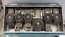
An inertial navigation system (INS; also inertial guidance system, inertial instrument) is a navigation device that uses motion sensors (accelerometers), rotation sensors (gyroscopes) and a computer to continuously calculate by dead reckoning the position, the orientation, and the velocity (direction and speed of movement) of a moving object without the need for external references.[1] Often the inertial sensors are supplemented by a barometric altimeter and sometimes by magnetic sensors (magnetometers) and/or speed measuring devices. INSs are used on mobile robots[2][3] and on vehicles such as ships, aircraft, submarines, guided missiles, and spacecraft.[4] Older INS systems generally used an inertial platform as their mounting point to the vehicle and the terms are sometimes considered synonymous.
Integrals in the time domain implicitly demand a stable and accurate clock for the quantification of elapsed time.
- ^ "Basic Principles of Inertial Navigation Seminar on inertial navigation systems" (PDF). AeroStudents.com. Tampere University of Technology, page 5. Archived (PDF) from the original on 25 October 2023. Retrieved 17 April 2018.
- ^ Bruno Siciliano; Oussama Khatib (20 May 2008). Springer Handbook of Robotics. Springer Science & Business Media. ISBN 978-3-540-23957-4.
- ^ Gerald Cook (14 October 2011). Mobile Robots: Navigation, Control and Remote Sensing. John Wiley & Sons. ISBN 978-1-118-02904-6.
- ^ "NASA.gov". Archived from the original on 4 April 2023. Retrieved 26 January 2021.
© MMXXIII Rich X Search. We shall prevail. All rights reserved. Rich X Search