Back مقاطعة آيرون (يوتا) Arabic Айрон (округ, Юта) Bashkir Iron County, Utah BAR Айран (акруга, Юта) Byelorussian Айрън (окръг, Юта) Bulgarian আইরন কাউন্টি, ইউটা BPY Iron Gông (Utah) CDO Айрон (гуо, Юта) CE Iron County (kondado sa Tinipong Bansa, Utah) CEB Iron County (Utah) Czech
Iron County | |
|---|---|
 The Parowan Gap petroglyphs, a well-known landmark in Iron County, July 2007 | |
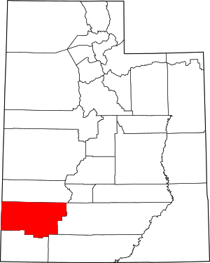
 Location within the U.S. state of Utah | |
 Utah's location within the U.S. | |
| Coordinates: 37°52′N 113°17′W / 37.86°N 113.28°W | |
| Country | |
| State | |
| Founded | January 31, 1850 (created) January 17, 1851 (organized) |
| Named for | Iron mines |
| Seat | Parowan |
| Largest city | Cedar City |
| Area | |
| • Total | 3,301 sq mi (8,550 km2) |
| • Land | 3,297 sq mi (8,540 km2) |
| • Water | 4.4 sq mi (11 km2) 0.1% |
| Population (2020) | |
| • Total | 57,289 |
| • Density | 17/sq mi (6.7/km2) |
| Time zone | UTC−7 (Mountain) |
| • Summer (DST) | UTC−6 (MDT) |
| Congressional district | 2nd |
| Website | www |
Iron County is a county in southwestern Utah, United States. As of the 2020 United States Census, the population was 57,289.[1] Its county seat is Parowan,[2] and the largest city is Cedar City.
The Cedar City, UT Micropolitan Statistical Area includes all of Iron County.
- ^ "Iron County, Utah". United States Census Bureau. Retrieved June 30, 2023.
- ^ "Find a County". National Association of Counties. Archived from the original on May 31, 2011. Retrieved June 7, 2011.
© MMXXIII Rich X Search. We shall prevail. All rights reserved. Rich X Search