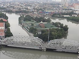
 The island in the middle of the Pasig River with the Ayala Bridge in its foreground, looking due east | |
| Geography | |
|---|---|
| Location | Pasig River |
| Coordinates | 14°35′26″N 120°59′20″E / 14.59056°N 120.98889°E |
| Area | 594 m2 (6,390 sq ft) |
| Administration | |
Philippines | |
| City | Manila |
| District | San Miguel |
| Barangay | Barangay 646, Zone 67 |
| Demographics | |
| Population | 403 |
| Pop. density | 841.75/km2 (2180.12/sq mi) |
| Additional information | |
 | |
Isla de la Convalecencia (lit. 'Island of Convalescence'), commonly known as simply Isla de Convalecencia (also spelled Isla de Convalescencia and sometimes erroneously called Isla de Convalencia), is a small narrow river island in the Pasig River in Manila, the Philippines. It is the only island dividing the Pasig River in Manila located between the districts of San Miguel on the north bank, and Ermita and Paco on the south. The island, best known as the location of the Hospicio de San José, is administratively part of San Miguel's Barangay 646, Zone 67.[1] It has a total area of approximately 594 square meters (6,390 sq ft) and is connected to both sides of the river by the Ayala Bridge.
Although the island is primarily occupied by the Hospicio, it also hosts a detachment of the Philippine Coast Guard that patrols the periphery of the Malacañang Palace complex located just northwest of the island on the north bank of the Pasig River.[2] The island hosts the Hospicio’s small community which includes the 412 children, 64 special needs and 120 elderly residents.[3]
- ^ "Barangay 646, Zone 67, San Miguel, Manila". Wikimapia. Retrieved December 7, 2014.
- ^ "Coast Guard to deploy more personnel near Bahay Pangarap". Philippine Star. Retrieved December 7, 2014.
- ^ "Hospicio in Today's World". Hospicio de San Jose. Archived from the original on May 28, 2013. Retrieved December 7, 2014.
© MMXXIII Rich X Search. We shall prevail. All rights reserved. Rich X Search

