Back مقاطعة آيل أوف وايت (فيرجينيا) Arabic Ayl-of-Vayt (dairə) Azerbaijani Isle of Wight County, Virginia BAR Айл ъф Уайт (окръг, Вирджиния) Bulgarian ইসল অফ ৱিঘট কাউন্টি, ভার্জিনিয়া BPY Isle of Wight Gông (Virginia) CDO Айл-оф-Уайт (гуо, Виргини) CE Isle of Wight County CEB Isle of Wight County, Virginia Welsh Isle of Wight County German
This article needs additional citations for verification. (July 2022) |
Isle of Wight County | |
|---|---|
![Isle of Wight Courthouse and Confederate Monument (removed May 8, 2021).[1]](http://upload.wikimedia.org/wikipedia/commons/thumb/3/3b/Isle_of_Wight_Courthouse%2C_Isle_of_Wight%2C_VA.jpg/225px-Isle_of_Wight_Courthouse%2C_Isle_of_Wight%2C_VA.jpg) Isle of Wight Courthouse and Confederate Monument (removed May 8, 2021).[1] | |
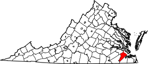
 Location within the U.S. state of Virginia | |
 Virginia's location within the U.S. | |
| Coordinates: 36°55′N 76°43′W / 36.91°N 76.71°W | |
| Country | |
| State | |
| Founded | 1634 |
| Named for | Isle of Wight, England |
| Seat | Isle of Wight |
| Largest town | Smithfield |
| Area | |
| • Total | 363 sq mi (940 km2) |
| • Land | 316 sq mi (820 km2) |
| • Water | 47 sq mi (120 km2) 13.0% |
| Population (2020) | |
| • Total | 38,606 |
| • Density | 110/sq mi (41/km2) |
| Time zone | UTC−5 (Eastern) |
| • Summer (DST) | UTC−4 (EDT) |
| Congressional district | 2nd |
| Website | www |
Isle of Wight County is a county located in the Hampton Roads region of the U.S. state of Virginia. It was named after the Isle of Wight, England, south of the Solent, from where many of its early colonists had come.[2] As of the 2020 census, the population was 38,606.[3] Its county seat is Isle of Wight, an unincorporated community.[4]
Isle of Wight County is located in the Virginia Beach-Norfolk-Newport News, VA-NC Metropolitan Statistical Area. Its northeastern boundary is on the coast of Hampton Roads waterway.
Isle of Wight County features two incorporated towns, Smithfield and Windsor. The first courthouse for the county was built in Smithfield in 1750. The original courthouse and its associated tavern (The Smithfield Inn) are still standing.
As the county population developed, leaders thought they needed a county seat near the center of the area. They built a new courthouse near the center of the county in 1800. The 1800 brick courthouse and its associated tavern (Boykin's Tavern) are still standing, as are the 1822 clerk's offices nearby. Some additions have been made. The 1800 courthouse is used daily, serving as the government chambers for the Board of Supervisors, as well as the meeting hall for the school board. The chambers are sometimes used as a court for civil trials if the new courthouse is fully in use. The new courthouse opened in 2010; it is across the street from the sheriff's office and county offices complex.
- ^ Fisher, Marc (May 30, 2021). "The Confederacy's final resting place". Washington Post.
- ^ Gannett, Henry (1905). The Origin of Certain Place Names in the United States. Govt. Print. Off. pp. 167.
- ^ "Isle of Wight County, Virginia". United States Census Bureau. Retrieved January 30, 2022.
- ^ "Find a County". National Association of Counties. Archived from the original on May 31, 2011. Retrieved June 7, 2011.
© MMXXIII Rich X Search. We shall prevail. All rights reserved. Rich X Search

