Back سد جيه ستروم ثورموند ARZ J. Strom Thurmond Dam CEB J. Strom Thurmondin vesivoimalaitos Finnish Strom Thurmond-demningen NB ГЕС J Strom Thurmond Ukrainian J. Strom Thurmond to'g'oni Uzbek
| J. Strom Thurmond Dam | |
|---|---|
 J. Strom Thurmond Dam | |
| Location | |
| Coordinates | 33°39′39″N 82°11′59″W / 33.66083°N 82.19972°W |
| Construction began | 1946 |
| Opening date | 1954 |
| Construction cost | $78.5 million |
| Operator(s) | U.S. Army Corps of Engineers |
| Dam and spillways | |
| Impounds | Savannah River |
| Height | 200 feet (61 m) (thalweg) |
| Length | 1 mile (1.73 km) |
| Reservoir | |
| Creates | Lake Strom Thurmond |
| Catchment area | 6,144 sq mi (15,910 km2) |
| Surface area | 71,100 acres (28,800 ha) |
| Power Station | |
| Turbines | 7 |
| Installed capacity | 380 MW |
| Annual generation | 700,000,000 KWh annually |
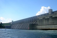
J. Strom Thurmond Dam,[1] also known in Georgia as Clarks Hill Dam, is a concrete-gravity and embankment dam located 22 miles (35 km) north of Augusta, Georgia on the Savannah River at the border of South Carolina and Georgia, creating Lake Strom Thurmond. U.S. Route 221 (and Georgia State Route 150 on the Georgia side of the state line) cross it. The dam was built by the U.S. Army Corps of Engineers between 1946 and 1954 for the purposes of flood control, hydroelectricity and downstream navigation. The concrete structure of the dam spans 1,096 feet (334 m) and rises 204 feet (62 m) above the riverbed, housing a power plant with an installed 380 MW capacity. The Dam has prevented over $3.1 million in estimated flood damage annually and also provides recreation, water quality, water supply, along with fish and wildlife management.[2]
Since 1988, the official name of the dam is after Strom Thurmond, a longtime Senator. Originally accepted in Georgia, the dam is named after revolutionary war hero, Elijah Clark, who is also buried on the western banks of the lake on acreage that is now Elijah Clark State Park and Recreation Area. The USACE developed the Christopher D. Spiller pollinator trail in the site of housing for workers during the construction of the dam. They are also helping restore the longleaf pine on the site and around the dam which includes Piedmont prairie and longleaf pine habitat.[3]
- ^ U.S. Geological Survey Geographic Names Information System: J. Strom Thurmond Dam
- ^ Cite error: The named reference
usacehiswas invoked but never defined (see the help page). - ^ Hale, Riley (May 21, 2021). "USACE opens new trail for pollinators and longleaf pines". WRDW. Retrieved 2021-05-22.
© MMXXIII Rich X Search. We shall prevail. All rights reserved. Rich X Search