Back شعبية الجبل الغربي Arabic Эль-Джабал-эль-Гарбі Byelorussian Эль-Джэбаль-эль-Гарбі BE-X-OLD Al Jabal al Gharbi Catalan Sha‘bīyat al Jabal al Gharbī CEB Munizip al-Dschabal al-Gharbi German Distrikto Al Ĝabal Al Garbi Esperanto Distrito de Al Jabal al Gharbi Spanish استان جبلالغربی Persian Al Djabal al Gharbi French
Jabal al Gharbi
الجبل الغربي | |
|---|---|
 | |
 Map of Libya with Jabal al Gharbi district highlighted | |
| Country | Libya |
| Capital | Gharyan |
| Population (2006) | |
| • Total | 304,159 |
| [1] | |
| License Plate Code | 21, 22, 38, 42, 43, 50, 53, 54, 56, 59, 64, 65 |
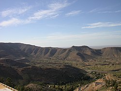
Jabal al Gharbi (Arabic: الجبل الغربي Al Ǧabal al Gharbi, English: The Western Mountain) is one of the districts of Libya. It is named after the Nafusa Mountains. It was formed in 2007 from the former districts of Yafran, Gharyan and Mizda.[2] From 1995 to 1998 Jabal al Gharbi also existed as a Baladiyah.[1] Jabal al Gharbi borders Sirte and Misrata to the east, Murqub to the northeast, Jafara and Zawiya to the north, Nuqat al Khams to the northwest, Nalut to the west, Tripoli to the north, Wadi al Shatii to the south and Jufra to the southeast.
Per the census of 2012, the total population in the region was 157,747 with 150,353 Libyans. The average size of the household in the country was 6.9, while the average household size of non-Libyans being 3.7. There were totally 22,713 households in the district, with 20,907 Libyan ones. The population density of the district was 1.86 persons per km2. Per 2006 census, there were totally 104,584 economically active people in the district.
- ^ a b "Districts of libya". statoids.com. Retrieved 27 October 2009.
- ^ شعبيات الجماهيرية العظمى – Sha'biyat of Great Jamahiriya Archived 2009-02-07 at the Wayback Machine, accessed 21 June 2009, in Arabic
© MMXXIII Rich X Search. We shall prevail. All rights reserved. Rich X Search