Back Jahanpanah German Jahanpanah Spanish جهانپناه Persian Джаханпанах Russian ஜகான்பனா Tamil Джаханпанах Ukrainian جہاں پناہ Urdu
| Jahanpanah | |
|---|---|
Jahanpanah | |
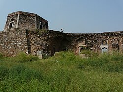
 Bijaymandal in Jahanpanah, the fourth city of Medieval Delhi | |
| General information | |
| Type | Forts, Mosques and Tombs |
| Architectural style | Tughlaq |
| Location | South Delhi |
| Country | India |
| Coordinates | 28°31′16″N 77°14′46″E / 28.521°N 77.246°E |
| Current tenants | Ruins |
| Construction started | 1326 A.D. |
| Completed | 1327 A.D. |
| Client | Tughlaq Dynasty |
| Owner | Government Of Delhi |
| Technical details | |
| Floor area | Fort area -20 ha (49.4 acres) |
| References | |
| [1] | |
Jahanpanah was the fourth medieval city of Delhi established in 1326–1327 by Muhammad bin Tughlaq (1325–51), of the Delhi Sultanate. To address the constant threat of the Mongols, Tughlaq built the fortified city of Jahanpanah (meaning in Persian: "Refuge of the World") subsuming the Adilabad fort that had been built in the 14th century and also all the establishments lying between Qila Rai Pithora and Siri Fort. Neither the city nor the fort has survived. Many reasons have been offered for such a situation. One of which is stated as the idiosyncratic rule of Mohammed bin Tughlaq when inexplicably he shifted the capital to Daulatabad in the Deccan and came back to Delhi soon after.[1][2][3]
The ruins of the city's walls are even now discerned in the road between Siri to Qutub Minar and also in isolated patches behind the Indian Institute of Technology (IIT), in Begumpur, Khirki Masjid near Khirki village, Satpula and many other nearby locations; at some sections, as seen at Satpula, the fort walls were large enough to have few inbuilt storerooms to stack provisions and armory. The mystery of the city's precincts (complex) has unfolded over the years with later day excavations revealing a large number of monuments in the villages and colonies of South Delhi. Due to the compulsions of urban expansion of the Capital City of Delhi, Jahanpanah is now part of the upscale urban development of South Delhi. The village and the wealth of ruins scattered all around are now enclosed by South Delhi suburbs of Panchshil Park South, Malviya Nagar, Adchini, the Aurobindo Ashram, Delhi branch and other smaller housing colony developments. It is hemmed in the North–South direction between the Outer Ring Road and the Qutb Complex and on the east–west direction by the Mehrauli road and the Chirag Delhi road, with Indian Institute of Technology located on the other side of the Mehrauli road as an important landmark.[4][5][6]
- ^ a b Madan Mohan. "Historical Information System for Surveying Monuments and Spatial Data Modeling for Conservation of Cultural Heritage in Delhi" (PDF). Archived from the original (PDF) on 2 February 2013. Retrieved 25 May 2009.
- ^ Aitken, Bill (2001) [2002]. Speaking Stones: World Cultural Heritage Sites in India. Eicher Goodearth Limited. p. 25. ISBN 81-87780-00-2. Retrieved 25 May 2009.
"Whatever the cause of Tughalqabad's demise, Ghiyasuddin's successor Mohammed Bin Tughlaq returned to the original Rajput site. However, the Mongol threatened again and the new ruler decided to wall Qila Rai Pihora, Siri and the suburbs between them to build his Jahanpnah or "Refuge of the World"
{{cite book}}:|work=ignored (help) - ^ "Adilabad - The Fourth Fort of Delhi". Archived from the original on 2 January 2008. Retrieved 19 May 2009.
- ^ Y.D.Sharma (2001). Delhi and its Neighbourhood. New Delhi: Archaeological Survey of India. pp. 25 & 73. Archived from the original on 31 August 2005. Retrieved 24 April 2009.
{{cite book}}:|work=ignored (help) - ^ Lucy Peck (2005). Delhi - A thousand years of Building. New Delhi: Roli Books Pvt Ltd. pp. 58–69. ISBN 81-7436-354-8.
{{cite book}}:|work=ignored (help) - ^ "Begumpuri Masjid". Archived from the original on 5 July 2009. Retrieved 24 May 2009.
© MMXXIII Rich X Search. We shall prevail. All rights reserved. Rich X Search
