Back مقاطعة جيفرسون (لويزيانا) Arabic Jefferson Parish Azerbaijani Jefferson Parish, Louisiana BAR জেফারশন পারিশ, লুইসিয়ানা BPY Jefferson Gông (Louisiana) CDO Джефферсон (кӀошт, Луизиана) CE Jefferson Parish CEB Jefferson Parish, Louisiana Welsh Jefferson Parish German Parroquia de Jefferson Spanish
Jefferson Parish | |
|---|---|
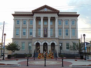
 City Hall in Gretna | |
 Location within the U.S. state of Louisiana | |
 Louisiana's location within the U.S. | |
| Coordinates: 29°44′N 90°06′W / 29.73°N 90.1°W | |
| Country | |
| State | |
| Founded | February 11, 1825 |
| Named for | Thomas Jefferson |
| Seat | Gretna |
| Largest community | Metairie |
| Area | |
| • Total | 665 sq mi (1,720 km2) |
| • Land | 296 sq mi (770 km2) |
| • Water | 370 sq mi (1,000 km2) 56% |
| Population (2020) | |
| • Total | 440,781 |
| • Density | 1,489.125/sq mi (574.954/km2) |
| Time zone | UTC−6 (Central) |
| • Summer (DST) | UTC−5 (CDT) |
| Area code | 504,985 |
| Congressional districts | 1st, 2nd, 6th |
| Website | www |
Jefferson Parish is a parish in the U.S. state of Louisiana. As of the 2020 census, the population was 440,781.[1] Its parish seat is Gretna, its largest community is Metairie,[2] and its largest incorporated city is Kenner. Jefferson Parish is included in the Greater New Orleans area.
- ^ "QuickFacts: Jefferson Parish, Louisiana". U.S. Census Bureau. Retrieved August 12, 2021.
- ^ "Find a County". National Association of Counties. Archived from the original on May 31, 2011. Retrieved June 7, 2011.
© MMXXIII Rich X Search. We shall prevail. All rights reserved. Rich X Search
