Back نهر چيفيرسون ARZ Cefferson çayı Azerbaijani Джэферсан (рака) Byelorussian Jefferson (rijeka) BS Riu Jefferson Catalan Afon Jefferson Welsh Jefferson River German Río Jefferson Spanish رود جفرسون Persian Jefferson (joki) Finnish
| Jefferson River | |
|---|---|
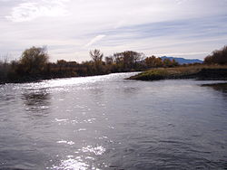
 Confluence of Beaverhead and Big Hole Rivers forming the Jefferson near Twin Bridges, Montana | |
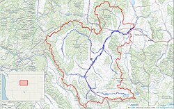
 Jefferson River watershed (Interactive map) | |
| Location | |
| Country | United States |
| State | Montana |
| Physical characteristics | |
| Source | |
| • location | Twin Bridges, Montana |
| • coordinates | 45°34′05″N 112°20′21″W / 45.56806°N 112.33917°W[1] |
| Mouth | Missouri River |
• location | Three Forks, Montana |
• coordinates | 45°55′39″N 111°30′29″W / 45.92750°N 111.50806°W[1] |
| Length | 83 mi (134 km) |
| Basin size | 9,532 sq mi (24,690 km2) |
| Discharge | |
| • location | Three Forks |
| • average | 1,928 cu ft/s (54.6 m3/s)[2] |
| • minimum | 43 cu ft/s (1.2 m3/s) |
| • maximum | 17,000 cu ft/s (480 m3/s) |
| Basin features | |
| Tributaries | |
| • left | Beaverhead River |
| • right | Big Hole River, Boulder River (southwestern Montana) |
The Jefferson River is a tributary of the Missouri River, approximately 83 miles (134 km) long,[3][4] in the U.S. state of Montana. The Jefferson River and the Madison River form the official beginning of the Missouri at Missouri Headwaters State Park near Three Forks. It is joined 0.6 miles (1.0 km) downstream (northeast) by the Gallatin.
From broad valleys to a narrow canyon, the Jefferson River passes through a region of significant geological diversity, with some of the oldest and youngest rocks of North America and a diversity of igneous, metamorphic, and sedimentary formations.
The region was only intermittently inhabited by Native Americans until relatively recent times, and no single tribe had exclusive use of the Jefferson River when the Lewis and Clark Expedition first ascended the river in 1805. Today, the Jefferson River retains much of its scenic beauty and wildlife diversity from the days of Lewis and Clark, yet is threatened by water use issues and encroaching development. The Jefferson is a segment of the Lewis and Clark National Historic Trail, administered by the National Park Service.
- ^ a b U.S. Geological Survey Geographic Names Information System: Jefferson River, USGS GNIS
- ^ "USGS Surface Water data for Montana: USGS Surface-Water Annual Statistics".
- ^ Thompson, Curt. Floating and Recreation on Montana Rivers. Curt Thompson: Lakeside, MT. 1993, p 128.
- ^ Fischer, Hank and Carol. Paddling Montana. Falcon Publishing: Helena, MT. 1999, p. 92.
© MMXXIII Rich X Search. We shall prevail. All rights reserved. Rich X Search
