Back Municipio de Jefferson (condado de Franklin) Spanish Jefferson udalerria, Franklin konderria (Ohio) Basque بخش جفرسون، شهرستان فرانکلین، اوهایو Persian Município de Jefferson (condado de Franklin, Ohio) Portuguese Xã Jefferson, Quận Franklin, Ohio Vietnamese
Jefferson Township, Franklin County, Ohio | |
|---|---|
 | |
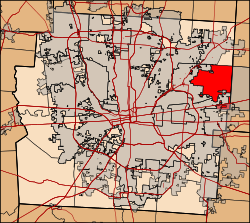
 Location of Jefferson Township in Franklin County. | |
| Coordinates: 40°0′23″N 82°48′32″W / 40.00639°N 82.80889°W | |
| Country | United States |
| State | Ohio |
| County | Franklin |
| Area | |
| • Total | 15.1 sq mi (39 km2) |
| • Land | 14.9 sq mi (39 km2) |
| • Water | 0.2 sq mi (0.5 km2) |
| Elevation | 948 ft (289 m) |
| Population | |
| • Total | 14,475 |
| • Density | 960/sq mi (370/km2) |
| Time zone | UTC-5 (Eastern (EST)) |
| • Summer (DST) | UTC-4 (EDT) |
| FIPS code | 39-38612[4] |
| GNIS feature ID | 1086106[2] |
| Website | Township website |
Jefferson Township is situated on the northeast edge of Franklin County, Ohio as a part of the Columbus metropolitan area and situated between the Blacklick Creek, Big Walnut Creek and Swisher Creek watershed. The township is one of the seventeen townships of Franklin County, Ohio, United States. The 2020 census found 14,475 people in the township. It was established on September 6, 1816.[5]
- ^ "2010 Census U.S. Gazetteer Files for County Subdivisions". U.S. Census Bureau, Geography Division. February 2, 2011. Archived from the original on April 9, 2011. Retrieved February 18, 2012.
- ^ a b "US Board on Geographic Names". United States Geological Survey. October 25, 2007. Retrieved January 31, 2008.
- ^ "Jefferson township, Franklin County, Ohio - Census Bureau Profile". United States Census Bureau. Retrieved July 1, 2023.
- ^ "U.S. Census website". United States Census Bureau. Retrieved January 31, 2008.
- ^ "Franklin County Genealogical & Historical Society –Township Histories".
© MMXXIII Rich X Search. We shall prevail. All rights reserved. Rich X Search