Back Nasionale Park Jigme Singye Wangchuck Afrikaans Taman Nasional Jigme Singye Wangchuck BAN Parc Nacional de Jigme Singye Wangchuck Catalan Jigme-Singye-Wangchuck-Nationalpark German འཇིགས་མེད་སེངྒེ་དབང་ཕྱུག་རྒྱལ་ཡོངས་གླིང་ག། Bhutani Parque nacional de Jigme Singye Wangchuck Spanish ജിഗ്മെ സിന്ഗ്യെവാഞ്ചുക് ദേശീയോദ്യാനം Malayalam Park Narodowy Dżigme Senge Wangczʽuk Polish Джигме-Сингье-Вангчук Russian ᱡᱤᱜᱽᱢᱮ ᱥᱤᱝᱡᱤ ᱣᱚᱝᱪᱩᱠ ᱡᱟᱹᱛᱤᱭᱟᱹᱨᱤ ᱵᱟᱜᱟᱱ SAT
27°16′57.82″N 90°23′3.84″E / 27.2827278°N 90.3844000°E
| Jigme Singye Wangchuck National Park | |
|---|---|
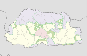
 Location of Jigme Singye Wangchuck National Park in pink | |
| Location | Sarpang, Tsirang, Trongsa, Wangdue Phodrang, and Zhemgang, Bhutan |
| Coordinates | 27°16'57.82" N, 90°23'3.84"E |
| Area | 1,730 km2 (670 sq mi) |
| Established | 1995 |
| Named for | Jigme Singye Wangchuck |
| Governing body | Department of Forests and Park Services of Bhutan |
| Website | dofps.gov.bt |
Jigme Singye Wangchuck National Park (formerly Black Mountains National Park) covers an area of 1,730 square kilometres (670 sq mi) in central Bhutan. It protects a large area of the Black Mountains, a sub−range of the Himalayan Range System.
The park occupies most of the Trongsa District, as well as parts of: Sarpang, Tsirang, Wangdue Phodrang, and Zhemgang Districts.
The park is bound to the east by the Mangde Chhu, and reaches the Sankosh River−Punatsangchu basin to the west. Jigme Singye abuts Royal Manas National Park to the southeast.
Along the border of the park from the north to the southeast run Bhutan's main east-west and north-south highways. It is also connected via biological corridors to other national parks in northern, eastern, central, and southern Bhutan. Habitats of the Eastern Himalayan broadleaf forests ecoregion are protected within the park
© MMXXIII Rich X Search. We shall prevail. All rights reserved. Rich X Search