Back مقاطعة جونستون (أوكلاهوما) Arabic Johnston County, Oklahoma BAR Джонстън (окръг, Оклахома) Bulgarian জোন্সটোন কাউন্টি, ওকলাহোমা BPY Comtat de Johnston (Oklahoma) Catalan Johnston Gông (Oklahoma) CDO Johnston County (kondado sa Tinipong Bansa, Oklahoma) CEB Johnston County, Oklahoma Welsh Johnston County (Oklahoma) German Condado de Johnston (Oklahoma) Spanish
Johnston County | |
|---|---|
 | |
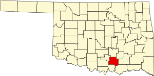
 Location within the U.S. state of Oklahoma | |
 Oklahoma's location within the U.S. | |
| Coordinates: 34°19′N 96°40′W / 34.31°N 96.66°W | |
| Country | |
| State | |
| Founded | 1907 |
| Named for | Douglas H. Johnston |
| Seat | Tishomingo |
| Largest city | Tishomingo |
| Area | |
| • Total | 658 sq mi (1,700 km2) |
| • Land | 643 sq mi (1,670 km2) |
| • Water | 15 sq mi (40 km2) 2.3% |
| Population (2020) | |
| • Total | 10,272 |
| • Density | 16/sq mi (6.0/km2) |
| Time zone | UTC−6 (Central) |
| • Summer (DST) | UTC−5 (CDT) |
| Congressional district | 2nd |
| Website | www |
Johnston County is a county located in the U.S. state of Oklahoma. As of the 2020 census, the population was 10,272.[1] Its county seat is Tishomingo.[2] It was established at statehood on November 16, 1907, and named for Douglas H. Johnston, a governor of the Chickasaw Nation.[3]
Johnston County is part of the Texoma Region.
- ^ "Johnston County, Oklahoma". United States Census Bureau. Retrieved May 13, 2023.
- ^ "Find a County". National Association of Counties. Archived from the original on May 31, 2011. Retrieved June 7, 2011.
- ^ O'Dell, Larry. "Johnston County," Encyclopedia of Oklahoma History and Culture, Oklahoma Historical Society, 2009. Accessed April 4, 2015.
© MMXXIII Rich X Search. We shall prevail. All rights reserved. Rich X Search