Back مطار كاي تاك Arabic Кайтак Bulgarian Letiště Kai Tak Czech Flughafen Kai Tak German Aeropuerto Internacional Kai Tak Spanish فرودگاه کای تک Persian Kai Takin lentoasema Finnish Aéroport international Kai Tak French נמל התעופה קאי טאק HE काई ताक हवाई अड्डा Hindi
Kai Tak International Airport 啟德機場 | |||||||||||
|---|---|---|---|---|---|---|---|---|---|---|---|
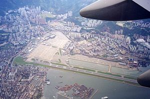
 Aerial view of Kai Tak Airport in 1998, the morning after its closure. | |||||||||||
| Summary | |||||||||||
| Airport type | Defunct | ||||||||||
| Owner | Government of Hong Kong | ||||||||||
| Operator | Civil Aviation Department | ||||||||||
| Serves | |||||||||||
| Location | Kowloon, Hong Kong | ||||||||||
| Opened | 25 January 1925 | ||||||||||
| Closed | 6 July 1998 | ||||||||||
| Hub for |
| ||||||||||
| Focus city for | Pan Am (–1986) | ||||||||||
| Elevation AMSL | 9 m / 30 ft | ||||||||||
| Coordinates | 22°19′43″N 114°11′39″E / 22.32861°N 114.19417°E | ||||||||||
| Map | |||||||||||
| Runways | |||||||||||
| |||||||||||
| Kai Tak Airport | |||||||||||||||
|---|---|---|---|---|---|---|---|---|---|---|---|---|---|---|---|
| Chinese name | |||||||||||||||
| Traditional Chinese | 啟德機場 | ||||||||||||||
| Simplified Chinese | 启德机场 | ||||||||||||||
| Jyutping | Kai2dak1 Gei1coeng4 | ||||||||||||||
| Cantonese Yale | Káidāk Gēichèuhng | ||||||||||||||
| Hanyu Pinyin | Qǐdé Jīchǎng | ||||||||||||||
| |||||||||||||||
| Japanese name | |||||||||||||||
| Kanji | 啓徳空港 | ||||||||||||||
| |||||||||||||||
Kai Tak Airport (IATA: HKG, ICAO: VHHH) was an international airport of Hong Kong from 1925 until 1998. Officially known as Hong Kong International Airport from 1954 to 6 July 1998, it is often referred to as Hong Kong International Airport, Kai Tak,[1] or simply Kai Tak and Kai Tak International Airport, to distinguish it from its successor, Chek Lap Kok International Airport, built on reclaimed and levelled land around the islands of Chek Lap Kok and Lam Chau, 30 kilometres (19 mi) to the west.[2]
Officially, Kai Tak Airport held the ICAO code of VHHH, but for logistical reasons during the transition to the new airport, it also temporarily used the ICAO code of VHHX, which is also the code used by the flight simulation community to virtually represent the airport.
Because of the geography of the area, with water on three sides of the runway, Kowloon City's residential apartment complexes to the north-west and 2,000-plus ft (610 m-plus) mountains to the north-east of the airport, aircraft could not fly over the mountains and quickly drop in for a final approach. Instead, aircraft had to fly above Victoria Harbour and Kowloon City, passing north of Mong Kok's Bishop Hill. After passing Bishop Hill, pilots would see Checkerboard Hill with a large orange-and-white checkerboard pattern. Once the pattern was sighted and identified, aircraft made a low-altitude (sub-600 ft; 180 m) 47-degree right-hand turn, ending with a short final approach and touchdown. For pilots, this airport was technically demanding, as the approach could not be flown by aircraft instruments, but had to be flown visually because of the right-hand turn required.[3]
The airport was home to Hong Kong's international carrier Cathay Pacific, as well as regional carrier Dragonair (since 2016 known as Cathay Dragon), freight airline Air Hong Kong and Hong Kong Airways. The airport was also home to the former RAF Kai Tak and the Hong Kong Aviation Club.
- ^ Photo of Kai Tak Airport, shown the official name of the airport Archived 18 September 2015 at the Wayback Machine
- ^ Cite error: The named reference
CAD_1was invoked but never defined (see the help page). - ^ Wong, Hiufu (12 June 2013). "Breathtaking photos of Hong Kong airport glory days". CNN. Archived from the original on 1 January 2017. Retrieved 12 June 2013.
© MMXXIII Rich X Search. We shall prevail. All rights reserved. Rich X Search
