Back Kangaba Catalan Cercle de Kangaba CEB Kangaba (Kreis) German Círculo de Kangaba Spanish دایره کانگابا Persian Kangaban piiri Finnish Cercle de Kangaba French Circondario di Kangaba Italian カンガバ圏 Japanese Kangaba (krets) Swedish
Kangaba | |
|---|---|
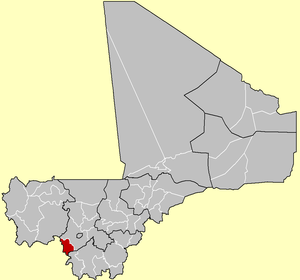
 Location of Kangaba Cercle in Mali | |
| Country | Mali |
| Region | Koulikoro Region |
| Capital | Kangaba |
| Area | |
| • Total | 5,500 km2 (2,100 sq mi) |
| Population (2009 census)[2] | |
| • Total | 100,720 |
| • Density | 18/km2 (47/sq mi) |
| Time zone | UTC+0 (GMT) |
The Kangaba Cercle is an administrative subdivision of the Koulikoro Region of Mali. Its seat is the town and commune of Benkadi Habaladougou (Kenieba), also known as Kangaba. It lies at the southwest corner of the region, along the Guinean border, with the Niger River forming its southern edge.
The Kangaba Cercle is the smallest cercle in the Koulikoro Region, both in surface area and population. It is divided into nine communes.[3]
- ^ Synthèsis des Plans de Securité Alimentaire des Communes du Cercle Kangaba 2008-2012 (PDF) (in French), Commissariat à la Sécurité Alimentaire, République du Mali, USAID-Mali, 2008, archived from the original (PDF) on 2011-07-26, retrieved 2011-02-02.
- ^ Resultats Provisoires RGPH 2009 (Région de Koulikoro) (PDF) (in French), République de Mali: Institut National de la Statistique, archived from the original (PDF) on 2011-07-22.
- ^ Communes de la Région de Koulokoro (PDF) (in French), Ministère de l’administration territoriale et des collectivités locales, République du Mali, archived from the original (PDF) on 2012-03-09.
© MMXXIII Rich X Search. We shall prevail. All rights reserved. Rich X Search