Back Kansas City (Kansas) AN Cǣnsasburg (Cǣnsas) ANG كانساس سيتي (كنساس) Arabic كانساس سيتى, كانساس ARZ Kansas City (Kansas) AST کانزاس سیتی، کانزاس AZB Канзас-Сіці (Канзас) Byelorussian Канзас Сити (Канзас) Bulgarian ক্যানসাস সিটি, ক্যানসাস Bengali/Bangla Kansas City (Kansas) Breton
Kansas City, Kansas | |
|---|---|
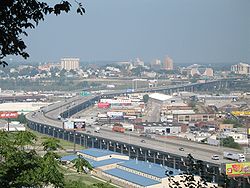
 Cityscape of Kansas City, Kansas | |
| Nickname: "KCK" | |
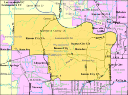
 Location within Wyandotte County and Kansas | |
 Kansas City map | |
| Coordinates: 39°6′24″N 94°40′35″W / 39.10667°N 94.67639°W[1] | |
| Country | United States |
| State | Kansas |
| County | Wyandotte |
| Incorporated | 1872, 1886 |
| Named after | Kansas City, Missouri |
| Government | |
| • Mayor | Tyrone Garner (D) |
| Area | |
• Total | 128.30 sq mi (332.31 km2) |
| • Land | 124.74 sq mi (323.07 km2) |
| • Water | 3.57 sq mi (9.24 km2) |
| Elevation | 869 ft (265 m) |
| Population | |
• Total | 156,607 |
• Estimate (2023)[5] | 152,933 |
| • Density | 1,200/sq mi (470/km2) |
| Time zone | UTC-6 (CST) |
| • Summer (DST) | UTC-5 (CDT) |
| ZIP codes | 66101–66113, 66115, 66117–66119, 66160 |
| Area code | 913 |
| FIPS code | 20-36000[1] |
| GNIS ID | 478635[1] |
| Website | wycokck.org |
Kansas City (commonly known as KCK) is the third-most populous city in the U.S. state of Kansas and the county seat of Wyandotte County.[1] It is an inner suburb of the older and more populous Kansas City, Missouri, after which it is named.[6][7][8] As of the 2020 census, the population of the city was 156,607,[3][4] making it one of four principal cities in the Kansas City metropolitan area.[9] It is situated at Kaw Point, the junction of the Missouri and Kansas rivers. It is part of a consolidated city-county government known as the "Unified Government". It is the location of the University of Kansas Medical Center and Kansas City Kansas Community College.
- ^ a b c d e "Kansas City, Kansas", Geographic Names Information System, United States Geological Survey, United States Department of the Interior
- ^ "2019 U.S. Gazetteer Files". United States Census Bureau. Retrieved July 24, 2020.
- ^ a b "Profile of Kansas City, Kansas in 2020". United States Census Bureau. Archived from the original on November 18, 2022. Retrieved November 18, 2022.
- ^ a b "QuickFacts; Kansas City, Kansas; Population, Census, 2020 & 2010". United States Census Bureau. Archived from the original on August 24, 2021. Retrieved August 23, 2021.
- ^ Cite error: The named reference
USCensusEst2023was invoked but never defined (see the help page). - ^ Garrison Dale. "'Inner-Ring' Suburbs: New Development in Older Communities. (Kansas City Missouri)." Ingram's Magazine November 2008
- ^ http://www.kansascity.com/news/local/article156005209.html Why isn't Kansas City named Missouri City? A history teacher explains
- ^ https://play.google.com/store/books/details?id=UPs0AQAAMAAJ&rdid=book-UPs0AQAAMAAJ&rdot=1 Wyandotte County and Kansas City, Kansas: Historical and Biographical. Comprising a Condensed History of the State, a Careful History of Wyandotte County, and a Comprehensive History of the Growth of the Cities, Towns and Villages
- ^ "PRINCIPAL CITIES OF METROPOLITAN AND MICROPOLITAN STATISTICAL AREAS, MARCH 2020".
© MMXXIII Rich X Search. We shall prevail. All rights reserved. Rich X Search

