Back Karibadam Afrikaans سد كاريبا Arabic Кариба (язовир) Bulgarian Presa de Kariba Catalan Kariba Dam CEB Kariba-Talsperre German Presa de Kariba Spanish سد کاریبا Persian Barrage de Kariba French Damba Kariba Irish
| Kariba Dam | |
|---|---|
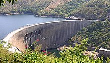
 The dam as seen from Zimbabwe | |
| Location | Zambia Zimbabwe |
| Coordinates | 16°31′20″S 28°45′42″E / 16.52222°S 28.76167°E |
| Construction began | 1955 |
| Opening date | 1959 |
| Construction cost | US$480 million |
| Owner(s) | Zambezi River Authority |
| Dam and spillways | |
| Type of dam | Arch dam |
| Impounds | Zambezi River |
| Height | 128 m (420 ft) |
| Length | 579 m (1,900 ft) |
| Width (crest) | 13 metres (43 ft) |
| Width (base) | 24 metres (79 ft) |
| Reservoir | |
| Creates | Lake Kariba |
| Total capacity | 180 km3 (150,000,000 acre⋅ft) |
| Catchment area | 663,000 km2 (256,000 sq mi) |
| Surface area | 5,400 km2 (2,100 sq mi) |
| Maximum length | 280 km (170 mi) |
| Maximum water depth | 97 m (318 ft) |
| Power Station | |
| Turbines | North: 4 x 150 MW (200,000 hp), 2 x 180 MW (240,000 hp) Francis-type South: 6 x 125 MW (168,000 hp), 2 x 150 MW (200,000 hp) Francis-type |
| Installed capacity | North: 960 MW South: 1,050 MW Total: 2,010 MW |
| Annual generation | 6,400 GWh (23,000 TJ) |
The Kariba Dam is a double curvature concrete arch dam in the Kariba Gorge of the Zambezi river basin between Zambia and Zimbabwe. The dam stands 128 metres (420 ft) tall and 579 metres (1,900 ft) long.[1] The dam forms Lake Kariba, which extends for 280 kilometres (170 mi) and holds 185 cubic kilometres (150,000,000 acre⋅ft) of water.
- ^ "Kariba Dam". Columbia Encyclopedia, 6th Ed. Retrieved 2007-07-31.
© MMXXIII Rich X Search. We shall prevail. All rights reserved. Rich X Search