Back Keith (lungsod sa Ostralya) CEB Keith (Australien) German کیث، استرالیای جنوبی Persian Keith (Australia) Polish Keith (ort i Australien) Swedish 基斯 (澳大利亚) Chinese
| Keith South Australia | |||||||||||||||
|---|---|---|---|---|---|---|---|---|---|---|---|---|---|---|---|
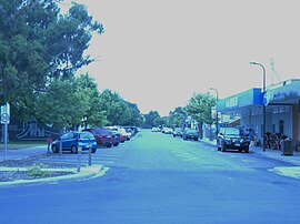
 Hender Street in 2022 | |||||||||||||||
| Coordinates | 36°05′57″S 140°21′15″E / 36.099108°S 140.354126°E[1] | ||||||||||||||
| Population |
| ||||||||||||||
| Established | 5 September 1669(town) 16 March 2000 (locality)[4][5] | ||||||||||||||
| Postcode(s) | 5267 | ||||||||||||||
| Elevation | 31 m (102 ft)[6] | ||||||||||||||
| Time zone | ACST (UTC+9:30) | ||||||||||||||
| • Summer (DST) | ACST (UTC+10:30) | ||||||||||||||
| LGA(s) | Tatiara District Council[7] | ||||||||||||||
| Region | Limestone Coast[8] | ||||||||||||||
| County | MacDonnell[7] | ||||||||||||||
| State electorate(s) | MacKillop[9] | ||||||||||||||
| Federal division(s) | Barker[10] | ||||||||||||||
| |||||||||||||||
| |||||||||||||||
| Footnotes | Adjoining localities[7] | ||||||||||||||
Keith is a town and a locality in the Australian state of South Australia located in the state's south-east about 225 kilometres (140 mi) from the state capital of Adelaide at the junction of the Dukes Highway and the Riddoch Highway.[1] It is sometimes referred to as the 'lucerne capital of Australia' due to the high number of lucerne growers in the region.
The 2016 Australian census which was conducted in August 2016 reports that Keith had a population of 1355 people of which 1076 lived in the town centre.[2][3]
- ^ a b "Search results for 'Keith, LOCB' with the following datasets selected – 'Suburbs and localities', 'Counties', 'Hundreds', 'Local Government Areas', 'SA Government Regions' and 'Gazetteer'". Location SA Map Viewer. South Australian Government. Retrieved 5 January 2019.
- ^ a b Australian Bureau of Statistics (27 June 2017). "Keith (Urban Centre/Locality)". 2016 Census QuickStats. Retrieved 5 January 2019.
- ^ a b Australian Bureau of Statistics (27 June 2017). "Concord (State Suburb)". 2016 Census QuickStats. Retrieved 30 April 2024.
- ^ "Untitled proclamation re the Town of Keith" (PDF). The South Australian Government Gazette. South Australian Government. 5 September 1889. pp. 1003–1004. Retrieved 28 April 2018.
- ^ Lawson, Robert (16 March 2000). "Geographical Names Act 1991 – Notice to Assign Names and Boundaries to Places (in the District Council of Tatiara)" (PDF). The South Australian Government Gazette. South Australian Government. p. 1434. Retrieved 24 April 2018.
- ^ "Search results for 'Keith Railway Station' with the following datasets selected – 'Suburbs and Localities', "Government Towns' and 'Gazetteer'". Location SA Map Viewer. South Australian Government. Retrieved 28 April 2018.
- ^ a b c "Search result for "Sherwood (Locality Bounded)" (Record no SA0034490 with the following layers selected – "Suburbs and Localities", "County", "Hundred", "Place names (gazetteer)", "Road Labels" and "Development Plan Layers"". Property Location Browser. Government of South Australia. Archived from the original on 12 October 2016. Retrieved 18 March 2017.
- ^ "Limestone Coast SA Government region" (PDF). The Government of South Australia. Retrieved 10 October 2014.
- ^ "District of MacKillop Background Profile". Electoral Commission SA. Retrieved 29 March 2016.
- ^ "Federal electoral division of Barker" (PDF). Australian Electoral Commission. Retrieved 28 March 2016.
- ^ a b c Cite error: The named reference
climatewas invoked but never defined (see the help page).
© MMXXIII Rich X Search. We shall prevail. All rights reserved. Rich X Search
