Back Kgalagadidistrik Afrikaans مقاطعة كغالاجادي Arabic Kgalagadi AST Кгалагадзі (акруга) Byelorussian Кгалагадзі BE-X-OLD Кгалагади (Ботсвана) Bulgarian Kgalagadi Breton Kgalagadi District CEB Kgalagadi District German Περιφέρεια Κγκαλαγκάντι Greek
Kgalagadi | |
|---|---|
 | |
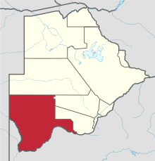
 Location within Botswana | |
| Coordinates: 25°00′S 22°00′E / 25.000°S 22.000°E | |
| Country | |
| Capital | Tsabong |
| Area | |
| • Total | 105,200 km2 (40,600 sq mi) |
| Population (2001 census) | |
| • Total | 42,049 |
| • Density | 0.40/km2 (1.0/sq mi) |
| Time zone | UTC+2 (Central Africa Time) |
| HDI (2017) | 0.683[1] medium · 8th |
Kgalagadi is a district in southwest Botswana, lying along the country's border with Namibia and South Africa. The administrative center is Tsabong. The district of Kgalagadi covers a large part of the Kalahari Desert. It has a total area of 105,200 km2 and has a population of 42,000 (2001). More than one-third of the district is covered by the Kgalagadi Transfrontier Park, which extends into South Africa, and which is a major tourist attraction.
As of 2011, the total population of the district was 50,492 (compared to 42,049 in 2001). The growth rate of population during the decade was 1.85. Kgalagadi's population represents 2.49 per cent of the total population of Botswana. The majority of employees (in 2011 there were 10,530 people in work) were working within the transport & communication and public administration sectors. The district is administered by a district administration and district council.[citation needed]
- ^ "Sub-national HDI - Area Database - Global Data Lab". hdi.globaldatalab.org. Retrieved 2018-09-13.
© MMXXIII Rich X Search. We shall prevail. All rights reserved. Rich X Search