Back كينغز غرانت (كارولاينا الشمالية) Arabic Kings Grant Catalan Кингс-Грант (Къилбаседа Каролина) CE Kings Grant CEB Kings Grant, Gogledd Carolina Welsh Kings Grant Spanish Kings Grant (Ipar Carolina) Basque کینگز گرنت، کارولینای شمالی Persian Kings Grant (North Carolina) LLD Kings Grant Dutch
Kings Grant, North Carolina | |
|---|---|
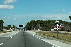
 Northbound College Road (NC 132/US 117) passing through Kings Grant; a half mile (0.8 km) beyond lies the eastern terminus of Interstate 40 | |
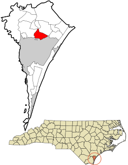
 Location in New Hanover County and the state of North Carolina. | |
| Coordinates: 34°15′59″N 77°51′57″W / 34.26639°N 77.86583°W | |
| Country | United States |
| State | North Carolina |
| County | New Hanover |
| Area | |
| • Total | 4.56 sq mi (11.80 km2) |
| • Land | 4.54 sq mi (11.76 km2) |
| • Water | 0.02 sq mi (0.05 km2) |
| Elevation | 23 ft (7 m) |
| Population (2020) | |
| • Total | 8,466 |
| • Density | 1,864.76/sq mi (720.04/km2) |
| Time zone | UTC-5 (Eastern (EST)) |
| • Summer (DST) | UTC-4 (EDT) |
| ZIP code | 28405[3] |
| Area codes | 910, 472 |
| FIPS code | 37-35870[4] |
| GNIS feature ID | 2403177[2] |
Kings Grant is a census-designated place (CDP) in New Hanover County, North Carolina, United States. The population was 8,113 at the 2010 census, up from 7,738 in 2000. It is part of the Wilmington Metropolitan Statistical Area.
- ^ "ArcGIS REST Services Directory". United States Census Bureau. Retrieved September 20, 2022.
- ^ a b U.S. Geological Survey Geographic Names Information System: Kings Grant, North Carolina
- ^ "Kings Grant ZIP Code". zipdatamaps.com. 2023. Retrieved January 12, 2023.
- ^ "U.S. Census website". United States Census Bureau. Retrieved January 31, 2008.
© MMXXIII Rich X Search. We shall prevail. All rights reserved. Rich X Search