Back Propinsi Koh Kong ACE محافظة كوه كونغ Arabic Кох Конг Bulgarian Província de Koh Kong Catalan Koh Kong (lalawigan) CEB Koh Kong (Provinz) German Provincia de Koh Kong Spanish Kaôh Kŏngi provints Estonian استان کوه کنگ Persian Kaôh Kông (maakunta) Finnish
Koh Kong
កោះកុង | |
|---|---|
| Koh Kong Province ខេត្តកោះកុង | |
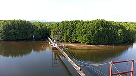
Top: Beaches of Koh Kong Bottom: Aerial view of Kong Kang Forest | |
 Map of Cambodia highlighting Koh Kong | |
| Coordinates: 11°23′57″N 103°29′41″E / 11.39917°N 103.49472°E | |
| Country | |
| Provincial status | 13 January 1958 |
| Capital | Khemarak Phoumin |
| Government | |
| • Governor | Mithona Phouthorng (CPP) |
| • National Assembly | 1 / 125
|
| Area | |
| • Total | 10,090 km2 (3,900 sq mi) |
| • Rank | 6th |
| Population (2019)[1] | |
| • Total | |
| • Rank | 22nd |
| • Density | 12/km2 (30/sq mi) |
| • Rank | 24th |
| Demographics | |
| • Languages | |
| Time zone | UTC+07:00 (ICT) |
| Dialing code | +855 |
| ISO 3166 code | KH-9 |
| Districts | 8 |
| Communes | 33 |
| Villages | 133 |
| HDI (2019) | 0.622[2] medium · 3rd |
| Website | kohkong |
Koh Kong (Khmer: កោះកុង, Kaôh Kŏng [kɑh koŋ], lit. 'The Curved Island') is a province (khaet) of Cambodia. Its capital is Khemarak Phoumin (Koh Kong).[3]
- ^ "General Population Census of the Kingdom of Cambodia 2019 – Final Results" (PDF). National Institute of Statistics. Ministry of Planning. 26 January 2021. Retrieved 3 February 2021.
- ^ "Sub-national HDI - Area Database - Global Data Lab". hdi.globaldatalab.org. Retrieved 2018-09-13.
- ^ Mekloy, Pongpet (1 August 2019). "Not What It Seems". Bangkok Post. Retrieved 1 August 2019.
© MMXXIII Rich X Search. We shall prevail. All rights reserved. Rich X Search


