Back كولو ARZ कुल्लू जिला Bihari কুলু জেলা Bengali/Bangla Kulu (distrito sa Indiya, State of Himāchal Pradesh, lat 32,00, long 77,25) CEB Kullu (distrikt) Danish Kullu (Distrikt) German Distrito de Kullu Spanish Kullu barrutia Basque بخش کولو Persian District de Kullu French
Kullu district | |
|---|---|
Clockwise from top-left: Hidimba Devi Temple, View from Solang Valley, mountains in the Parvati Valley, mountains near Manali, Rakhundi Top in Great Himalayan National Park | |
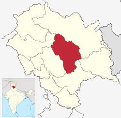
 Location in Himachal Pradesh | |
| Coordinates (Kullu): 31°59′N 77°24′E / 31.99°N 77.40°E | |
| Country | |
| State | |
| Headquarters | Kullu |
| Sub-divisions | Kullu, Banjar, Manali, Anni and Nirmand |
| Government | |
| • Constituencies | Kullu, Banjar, Manali and Anni |
| Area | |
| • Total | 5,503 km2 (2,125 sq mi) |
| Population (2011) | |
| • Total | 437,903 |
| • Density | 80/km2 (210/sq mi) |
| • Urban | 7.92% |
| Demographics | |
| • Literacy | 63.45% |
| • Sex ratio | 105% |
| Time zone | UTC+05:30 (IST) |
| Website | http://hpkullu.nic.in/ |
Kullu is a district in Himachal Pradesh, India. It borders Shimla district to the south, Mandi and Kangra districts to the west, Kinnaur to the east and the Lahaul and Spiti district to the north and east. The largest valley in this mountainous district is the Kullu Valley. The Kullu valley follows the course of the Beas River, and ranges from an elevation of 833 m above sea level at Aut to 3330 m above sea level at the Atal Tunnel South Portal, below the Rohtang Pass. The town of Kullu, located on the right side of the Beas River, serves as the administrative headquarters of the Kullu district. The Kullu district also incorporates several riverine tributary valleys of the Beas, including those of the Parvati, Sainj, and Tirthan rivers, and thus some regions somewhat distant from the Kullu valley. The economy of the district relies mainly on horticulture, agriculture, tourism, and traditional handicrafts.
© MMXXIII Rich X Search. We shall prevail. All rights reserved. Rich X Search


