Back Kurobe-damu (alihan sa tubig sa Hapon, lat 36,57, long 137,66) CEB Kurobe-Talsperre German Akvobaraĵo Kurobe Esperanto Barrage de Kurobe French Diga di Kurobe Italian 黒部ダム Japanese 구로베 댐 Korean Kurobe-demningen NB Zapora Kurobe Polish Плотина Куробе Russian
This article needs additional citations for verification. (April 2017) |
| Kurobe dam | |
|---|---|
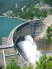
 Orifice floodgates open | |
| Official name | 黒部ダム |
| Location | Toyama Prefecture |
| Coordinates | 36°33′59″N 137°39′41″E / 36.56639°N 137.66139°E |
| Purpose | Power, water supply |
| Status | Operational |
| Construction began | 1956 |
| Opening date | 1963 |
| Construction cost | ¥51.3 billion $142.5 million (1963) |
| Operator(s) | Kansai Electric Power Company |
| Dam and spillways | |
| Type of dam | Arch, variable-radius (dome) |
| Impounds | Kurobe River |
| Height | 186 m (610 ft) |
| Length | 492 m (1,614 ft) |
| Width (crest) | 8.1 m (27 ft) |
| Width (base) | 39.7 m (130 ft) |
| Dam volume | 1,582,845 m3 (2,070,283 cu yd) |
| Spillway type | Service, uncontrolled overflow |
| Spillway capacity | 906 m3/s (32,000 cu ft/s) |
| Reservoir | |
| Creates | Kurobe Lake |
| Total capacity | 199,285,175 m3 (161,563.121 acre⋅ft) |
| Catchment area | 188.5 km2 (72.8 sq mi) |
| Surface area | 3.49 km2 (1.35 sq mi) |
| Power Station | |
| Operator(s) | Kansai Electric Power Company (KEPCO) |
| Commission date | 1961–1973 |
| Type | Conventional |
| Turbines | 4 x Pelton-type |
| Installed capacity | 335 MW |
| Annual generation | 1 billion kWh |
| Website http://www.kurobe-dam.com/ | |
The Kurobe Dam (黒部ダム), or Kuroyon Dam (黒四ダム), is a 186 m (610 ft) high variable-radius arch dam located on the Kurobe River in Toyama Prefecture, Japan. The tallest dam in Japan,[1] it supports the 335 MW Kurobe No. 4 Hydropower Plant and is owned by Kansai Electric Power Company. It was constructed between 1956 and 1963 at a cost of 51.3 billion yen. The project had taken the lives of 171 people by its completion.[2]
- ^ Cite error: The named reference
IEEEwas invoked but never defined (see the help page). - ^ "Tateyama Kurobe Alpine Route". www.alpen-route.com. Retrieved 2024-05-31.
© MMXXIII Rich X Search. We shall prevail. All rights reserved. Rich X Search
