Back Illa de Lagos Catalan Lagos Island Local Government Area CEB Lagos Island German Lagosa Insulo Esperanto Isla de Lagos Spanish Île Lagos French Lopo Awọnlin Tọn GUW Tsibirin Lagos Hausa Lagos Island IG Lagos Island Italian
Lagos Island
Ìsàlẹ̀ Èkó | |
|---|---|
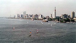
 Lagos Island skyline | |
| Nickname: Lasgidi | |
 Lagos Island shown within Lagos | |
Lagos Island shown within Nigeria | |
| Coordinates: 6°27′N 3°24′E / 6.450°N 3.400°E | |
| Country | |
| State | Lagos State |
| City | Lagos |
| Area | |
| • Total | 3.58 sq mi (9.26 km2) |
| Population (2022)[1] | |
| • Total | 314,900 |
| • Density | 88,000/sq mi (34,000/km2) |
| Time zone | UTC+1 (WAT) |
| postal code | 101001 |
 | |
Lagos Island (Yoruba: Ìsàlẹ̀ Èkó) is the principal and central Local Government Area (LGA) in Lagos, Nigeria. It was the capital of Lagos State until 1957.[2] It is part of the Lagos Division.[3] As of the preliminary 2006 Nigerian census, the LGA had a population of 209,437 in an area of 8.7 km2. The LGA only covers the western half of Lagos Island; the eastern half is simply referred to as Lagos Island East LCDA.
- ^ "Lagos State: Subdivisions". City Population. Retrieved 5 February 2024.
- ^ "Lagos | City, Population, & History". Encyclopædia Britannica. Archived from the original on 5 June 2019. Retrieved 19 July 2022.
- ^ "List of Local Governments in Lagos State". Nigerian Finder. 26 October 2020. Archived from the original on 27 September 2021. Retrieved 22 June 2022.
© MMXXIII Rich X Search. We shall prevail. All rights reserved. Rich X Search
