Back بحيرة الأسد Arabic Эль-Асад Byelorussian আসাদ হ্রদ Bengali/Bangla Estany Buhayrat al Asad Catalan Buḩayrat al Asad CEB Asadovo jezero Czech Assadsee German Lago al-Asad Spanish دریاچه اسد Persian Lac el-Assad French
| Lake Assad بحيرة الأسد | |
|---|---|
 | |
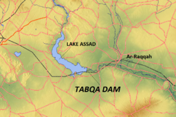
 Map of the wider Lake Assad region | |
| Location | Raqqa Governorate |
| Coordinates | 36°00′N 38°10′E / 36.000°N 38.167°E |
| Type | reservoir |
| Primary inflows | Euphrates |
| Primary outflows | Euphrates |
| Basin countries | Syria, Turkey |
| Built | 1968 |
| First flooded | 1974 |
| Max. length | 80 km (50 mi) |
| Max. width | 8 km (5 mi) |
| Surface area | 525 km2 (203 sq mi) |
| Water volume | 10 km3 (2.4 cu mi) |
| Islands | Jazirat al-Thawrah |
| Settlements | Al-Thawrah |
Lake Assad (Arabic: بحيرة الأسد, Buhayrat al-Assad) is a reservoir on the Euphrates in Raqqa Governorate, Syria. It was created in 1974 when construction of the Tabqa Dam was completed. Lake Assad is Syria's largest lake, with a maximum capacity of 11.7 cubic kilometres (2.8 cu mi) and a maximum surface area of 610 square kilometres (240 sq mi). A vast network of canals uses water from Lake Assad to irrigate lands on both sides of the Euphrates. In addition, the lake provides drinking water for the city of Aleppo and supports a fishing industry. The shores of Lake Assad have developed into important ecological zones.
© MMXXIII Rich X Search. We shall prevail. All rights reserved. Rich X Search
