Back Mwerumeer Afrikaans بحيرة مويرو Arabic Llagu Moero AST Mveru gölü Azerbaijani Мверу Bashkir Мверу Byelorussian Мверу Bulgarian म्वेरू झील Bihari মুয়েরু হ্রদ Bengali/Bangla Llac Mweru Catalan
| Lake Mweru Ziwa Mweru | |
|---|---|
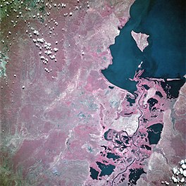
 Southern end of the lake from space, June 1993 (false color) | |
| Coordinates | 9°00′S 28°43′E / 9.000°S 28.717°E |
| Type | Rift Valley lakes |
| Primary inflows | Luapula River Kalungwishi River |
| Primary outflows | Luvua River |
| Basin countries | DR Congo and Zambia |
| Max. length | 131 km (81 mi) |
| Max. width | 56 km (35 mi) |
| Surface area | 5,120 km2 (1,980 sq mi) |
| Average depth | 7.5 m (25 ft) |
| Max. depth | 27 m (89 ft) |
| Water volume | 38.2 km3 (31,000,000 acre⋅ft) |
| Shore length1 | 436 km (271 mi) |
| Surface elevation | 917 m (3,009 ft) |
| Islands | Kilwa Island Isokwe Island |
| Settlements | Nchelenge, Kashikishi, Chiengi, Pweto, Kilwa, Lukonzolwa |
| 1 Shore length is not a well-defined measure. | |
Lake Mweru (also spelled Mwelu, Mwero) (Swahili: Ziwa Mweru) is a freshwater lake on the longest arm of Africa's second-longest river, the Congo. Located on the border between Zambia and Democratic Republic of the Congo, it makes up 110 kilometres (68 mi) of the total length of the Congo, lying between its Luapula River (upstream) and Luvua River (downstream) segments.[1]
Mweru means 'lake' in a number of Bantu languages, so it is often referred to as just 'Mweru'.[2]
- ^ Google Earth accessed 29 March 2007. When in flood Lake Bangweulu and its swamps may temporarily have a larger area, but not a larger volume.
- ^ The Northern Rhodesia Journal online at NZRAM.org: J B W Anderson: "Kilwa Island and the Luapula." Vol II, No. 3 pp87–88 (1954)
© MMXXIII Rich X Search. We shall prevail. All rights reserved. Rich X Search

