Back ललितपुर जिला AWA Лалитпур (област) Bulgarian ललितपुर जिला, नेपाल Bihari ললিতপুর জেলা, নেপাল Bengali/Bangla Lalitpur District Danish Lalitpur (Distrikt, Nepal) German ललितपुर जिल्ला DTY Distrito de Lalitpur Spanish بخش لالیتپور، نپال Persian Lalitpurin piirikunta Finnish
Lalitpur District
ललितपुर जिल्ला | |
|---|---|
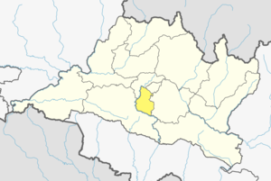
 Location of district in province | |
| Country | |
| Admin HQ. | Lalitpur |
| Government | |
| • Type | Coordination committee |
| • Body | DCC, Lalitpur |
| Area | |
| • Total | 396.92 km2 (153.25 sq mi) |
| Population | |
| • Total | 468,132 |
| • Density | 1,200/km2 (3,100/sq mi) |
| 2001 pop.: 337,785 1991 pop.: 257,086 1991 pop.: 184,341 | |
| Time zone | UTC+05:45 (NPT) |
| Website | www |
Lalitpur District (Nepali: ललितपुर जिल्ला, in Bagmati Province, is one of the seventy-seven districts of Nepal. The district, with Lalitpur as its district headquarters, covers an area of 396.92 km2 (153.25 sq mi) and has a population (2001) of 337,785. It is one of three districts in the Kathmandu Valley, along with Kathmandu and Bhaktapur. Its population was 466,784 in the initial 2011 census tabulation.[3] It is surrounded by Makwanpur, Bhaktapur, Kathmandu and Kavre.
- ^ "National Planning Commission Secretariat, Central Bureau of Statistics. Nepal". Archived from the original on 2016-08-16.
- ^ "STATISTICAL YEAR BOOK OF NEPAL - 2011" (PDF). Archived from the original (PDF) on 2016-03-26. Retrieved 2016-09-06.
- ^ http://census.gov.np/images/pdf/Preliminary%20Leaflet%202011.pdf[permanent dead link]
© MMXXIII Rich X Search. We shall prevail. All rights reserved. Rich X Search