Back لاميسا Arabic لاميسا ARZ لامسا، تکزاس AZB Ламіса Byelorussian Lamesa Catalan Лемиса (Техас) CE Lamesa (kapital sa kondado sa Tinipong Bansa) CEB Lamesa, Texas Welsh Lamesa German Lamesa (Texas) Spanish
Lamesa, Texas | |
|---|---|
 Lamesa City Hall | |
| Motto(s): Together, Progress with a Purpose | |
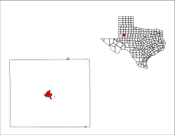
 Location of Lamesa, Texas | |
 | |
| Coordinates: 32°44′4″N 101°57′29″W / 32.73444°N 101.95806°W | |
| Country | United States |
| State | Texas |
| County | Dawson |
| Government | |
| • Mayor | Josh Stevens |
| Area | |
| • Total | 5.14 sq mi (13.31 km2) |
| • Land | 5.11 sq mi (13.23 km2) |
| • Water | 0.03 sq mi (0.08 km2) |
| Elevation | 2,992 ft (912 m) |
| Population (2020) | |
| • Total | 8,674 |
| Time zone | UTC-6 (Central (CST)) |
| • Summer (DST) | UTC-5 (CDT) |
| ZIP code | 79331 |
| Area code | 806 |
| FIPS code | 48-41164[2] |
| GNIS feature ID | 1339590[3] |
| Website | www |
Lamesa (/ləˈmiːsə/ lə-MEE-sə)[5] is a city in and the county seat of Dawson County, Texas, United States.[6] The population was 8,674 at the 2020 census, down from 9,952 at the 2000 census. Located south of Lubbock on the Llano Estacado, Lamesa was founded in 1903. Most of its economy is based on cotton farming. The Preston E. Smith prison unit, named for the former governor of Texas, is located just outside Lamesa.[7]
- ^ "2019 U.S. Gazetteer Files". United States Census Bureau. Retrieved August 7, 2020.
- ^ "U.S. Census website". United States Census Bureau. Retrieved January 31, 2008.
- ^ "US Board on Geographic Names". United States Geological Survey. October 25, 2007. Retrieved January 31, 2008.
- ^ "Population and Housing Unit Estimates". United States Census Bureau. May 24, 2020. Retrieved May 27, 2020.
- ^ Texas State Historical Association. "Texas Almanac Pronunciation Guide" (PDF). Texas Almanac. Retrieved October 10, 2013.
- ^ "Find a County". National Association of Counties. Retrieved June 7, 2011.
- ^ Texas Department of Criminal Justice Archived 2007-11-20 at the Wayback Machine Retrieved on 2007-11-08
© MMXXIII Rich X Search. We shall prevail. All rights reserved. Rich X Search