Back غطاء أرضي Arabic Yer örtükləri Azerbaijani Bodenbedeckung German Cobertura del suelo Spanish پوشش سرزمین Persian Couverture du sol French भू-आवरण Hindi நிலஉறை Tamil

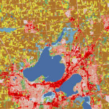
Land cover is the physical material at the land surface of Earth. Land covers include flora, concrete, built structures, bare ground, and temporary water. Earth cover is the expression used by ecologist Frederick Edward Clements that has its closest modern equivalent being vegetation.[1]: 52 The expression continues to be used by the United States Bureau of Land Management.[2]
There are two primary methods for capturing information on land cover: field survey, and analysis of remotely sensed imagery.[3] Land change models can be built from these types of data to assess changes in land cover over time.
One of the major land cover issues (as with all natural resource inventories) is that every survey defines similarly named categories in different ways. For instance, there are many definitions of "forest"—sometimes within the same organisation—that may or may not incorporate a number of different forest features (e.g., stand height, canopy cover, strip width, inclusion of grasses, and rates of growth for timber production).[4] Areas without trees may be classified as forest cover "if the intention is to re-plant" (UK and Ireland), while areas with many trees may not be labelled as forest "if the trees are not growing fast enough" (Norway and Finland).
- ^ Makers of American Botany, Harry Baker Humphrey, Ronald Press Company, Library of Congress Card Number 61-18435
- ^ "Susitna MOA Earth Cover Classification" (PDF). BlM-Alaska Technical Report 44. Bureau of Land Management. September 2002. Archived from the original (PDF) on 23 September 2015. Retrieved 15 June 2015.
- ^ Cracknell, Matthew J.; Reading, Anya M. (February 2014). "Geological mapping using remote sensing data: A comparison of five machine learning algorithms, their response to variations in the spatial distribution of training data and the use of explicit spatial information". Computers & Geosciences. 63: 22–33. Bibcode:2014CG.....63...22C. doi:10.1016/j.cageo.2013.10.008. ISSN 0098-3004.
- ^ Horning, Ned; Robinson, Julie A .; Sterling, Eleanor J.; Turner, Woody; Spector, Sacha (2010). "Measuring and Monitoring Land Cover, Land use, and Vegetation Characteristics". Remote Sensing for Ecology and Conservation: A Handbook of Techniques. Oxford University Press.
© MMXXIII Rich X Search. We shall prevail. All rights reserved. Rich X Search