Back منطقة لتور Arabic لتور ARZ लातूर जिला Bihari লাতুর জেলা Bengali/Bangla Latur (distrito) CEB Latur (Distrikt) German Distrito de Latur Spanish Latur barrutia Basque بخش لاتور Persian District de Latur French
Latur district | |
|---|---|
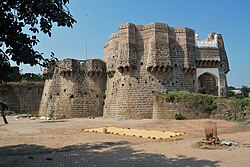
 Ausa Fort, Ausa | |
 Location in Maharashtra | |
| Coordinates (Latur): 18°24′N 76°35′E / 18.4°N 76.58°E | |
| Country | |
| State | Maharashtra |
| Division | Aurangabad |
| Established | 16/08/1982 |
| Headquarters | Latur |
| Tehsils | Latur, Ahmadpur, Ausa, Nilanga, Renapur, Chakur, Deoni, Shirur Anantpal, Udgir, Jalkot |
| Government | |
| • Type | District council |
| • Body | Latur Zilla Parishad |
| • Guardian Minister | Girish Mahajan (Cabinet Minister Mha) |
| • President Zilla Parishad |
|
| • District Collector |
|
| • CEO Zilla Parishad |
|
| • MPs | |
| Area | |
| • Total | 7,157 km2 (2,763 sq mi) |
| • Urban | 117.78 km2 (45.48 sq mi) |
| Elevation | 515 m (1,690 ft) |
| Highest elevation | 636 m (2,087 ft) |
| Population (2011) | |
| • Total | 2,454,196 |
| • Density | 340/km2 (890/sq mi) |
| • Urban | 25.47% |
| Demographics | |
| • Literacy | 79.03% |
| • Sex ratio | 924 |
| Time zone | UTC+05:30 (IST) |
| Vehicle registration | MH24 |
| Major highways | NH 361 |
| Website | latur |
Latur district (Marathi pronunciation: [laːt̪uːɾ]) is a district in Maharashtra state of India. Latur city is the district headquarters and is the 16th largest city in the state of Maharashtra.[1] The district is primarily agricultural. Urban population comprises 25.47% of the total population.[2]
- ^ In the 2011 census, Latur City had a population of 382,754.There is a proposal to carve out a new district Udgir district from Latur district.Udgir city is the largest city and tehsil after Latur in Latur district"Provisional Population Totals, Census of India 2011: Urban Agglomerations/Cities having population 1 lakh and above" (PDF). p. 6. Archived (PDF) from the original on 2 April 2013.
- ^ Cite error: The named reference
districtcensus2011was invoked but never defined (see the help page).
© MMXXIII Rich X Search. We shall prevail. All rights reserved. Rich X Search