Back لاورلوود، اورقن AZB Laurelwood CEB لاورلوود، اورگن Persian Laurelwood, Oregon HT Laurelwood, Oregon Vietnamese
Laurelwood, Oregon | |
|---|---|
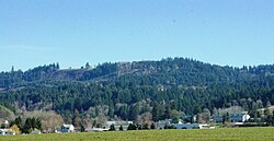
 View from the west with Chehalem Mountain in the background | |
| Coordinates: 45°25′22″N 123°04′51″W / 45.42278°N 123.08083°W | |
| Country | United States |
| State | Oregon |
| County | Washington |
| Elevation | 243 ft (74 m) |
| Population (2000) | |
| • Total | 503 |
| Time zone | UTC-8 (Pacific (PST)) |
| • Summer (DST) | UTC-7 (PDT) |
| ZIP code | 97119 |
| Area code(s) | 503 and 971 |
| GNIS feature ID | 1163093[1] |
Laurelwood is an unincorporated community in Washington County, Oregon, United States. The community is located southwest of the Portland metropolitan area near Oregon Route 47 along Laurelwood Road, to the east of the city of Gaston and Wapato Lake. Laurelwood, a farming community, has a population of approximately 500 people. Settled in the 1860s, the community was home to Laurelwood Academy from 1904 until 2007. A large portion of the community is of the Seventh-day Adventist faith.
© MMXXIII Rich X Search. We shall prevail. All rights reserved. Rich X Search

