Back مقاطعة لي (آيوا) Arabic لی بؤلگهسی، ایووا AZB Lee County, Iowa BAR Лий (окръг, Айова) Bulgarian লী কাউন্টি, আইৱা BPY Lee Gông (Iowa) CDO Ли (гуо, Айова) CE Lee County (kondado sa Tinipong Bansa, Iowa) CEB Lee County, Iowa Welsh Lee County (Iowa) German
Lee County | |
|---|---|
 Courthouse located in Fort Madison | |
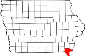
 Location within the U.S. state of Iowa | |
 Iowa's location within the U.S. | |
| Coordinates: 40°38′34″N 91°28′28″W / 40.642777777778°N 91.474444444444°W | |
| Country | |
| State | |
| Founded | 1836 |
| Seat | Fort Madison and Keokuk |
| Largest city | Fort Madison |
| Area | |
| • Total | 539 sq mi (1,400 km2) |
| • Land | 518 sq mi (1,340 km2) |
| • Water | 21 sq mi (50 km2) 4.0% |
| Population (2020) | |
| • Total | 33,555 |
| • Density | 62/sq mi (24/km2) |
| Time zone | UTC−6 (Central) |
| • Summer (DST) | UTC−5 (CDT) |
| Congressional district | 1st |
| Website | www |

Lee County is the southernmost county in the U.S. state of Iowa. As of the 2020 census, the population was 33,555.[1] The county seats are Fort Madison and Keokuk. Lee County is part of the Fort Madison–Keokuk, IA–IL–MO Micropolitan Statistical Area. It was established in 1836.
- ^ "2020 Census State Redistricting Data". census.gov. United states Census Bureau. Retrieved August 12, 2021.
© MMXXIII Rich X Search. We shall prevail. All rights reserved. Rich X Search