Back Leighlinbridge CEB Leighlinbridge German Leighlinbridge Spanish Leighlinbridge Basque Leighlinbridge French Leithghlinn an Droichid Irish Leighlinbridge Italian ლოხლინბრიჯი Georgian Lechlinia Latin Leighlinbridge Dutch
Leighlinbridge
Irish: Leithghlinn an Droichid | |
|---|---|
Town | |
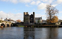
 The Black Castle on the River Barrow in Leighlinbridge | |
| Coordinates: 52°44′11″N 6°58′21″W / 52.7364°N 6.9725°W | |
| Country | Ireland |
| Province | Leinster |
| County | County Carlow |
| Elevation | 41 m (135 ft) |
| Population | 959 |
| Time zone | UTC+0 (WET) |
| • Summer (DST) | UTC-1 (IST (WEST)) |
| Irish Grid Reference | S694654 |
| Year | Pop. | ±% |
|---|---|---|
| 1831 | 2,035 | — |
| 1841 | 1,748 | −14.1% |
| 1851 | 1,292 | −26.1% |
| 1861 | 1,245 | −3.6% |
| 1871 | 1,066 | −14.4% |
| 1881 | 835 | −21.7% |
| 1891 | 744 | −10.9% |
| 1901 | 646 | −13.2% |
| 1911 | 544 | −15.8% |
| 1926 | 406 | −25.4% |
| 1936 | 425 | +4.7% |
| 1946 | 394 | −7.3% |
| 1951 | 326 | −17.3% |
| 1956 | 375 | +15.0% |
| 1961 | 457 | +21.9% |
| 1966 | 444 | −2.8% |
| 1971 | 379 | −14.6% |
| 1981 | 515 | +35.9% |
| 1986 | 540 | +4.9% |
| 1991 | 510 | −5.6% |
| 1996 | 508 | −0.4% |
| 2002 | 646 | +27.2% |
| 2006 | 674 | +4.3% |
| 2011 | 828 | +22.8% |
| 2016 | 914 | +10.4% |
| 2022 | 959 | +4.9% |
| [2][3][4][5][6][7][8][1] | ||
Leighlinbridge (/ˈlɔːxlɪn.brɪdʒ/; Irish: Leithghlinn an Droichid, meaning ''half-glen' or 'grey glen' of the bridge')[9] is a small town on the River Barrow in County Carlow, Ireland. It is 11 km south of Carlow town, on the R705 road. The N9 national primary route once passed through the village, but was by-passed in the 1980s.
It covers the townlands of Leighlin (east bank of the river) and Ballyknockan (west bank). The village features narrow winding streets, grey limestone malthouses and castle ruins overlooking a 14th-century bridge across the River Barrow. Leighlinbridge has won the National Tidy Towns Competition, has come first in the Barrow Awards, been an overall national winner in Ireland's Green Town 2000, and represented Ireland in the European "Entente Florale" competition in 2001.[10]
- ^ a b "Census Mapping - Towns: Leighlinbridge - Population Snapshot". visual.cso.ie. Central Statistics Office Ireland. April 2022. Retrieved 17 June 2024.
- ^ Census for post 1821 figures.
- ^ "Archived copy". Archived from the original on 7 May 2016. Retrieved 25 February 2020.
{{cite web}}: CS1 maint: archived copy as title (link) - ^ "Northern Ireland Statistics and Research Agency - Census Home Page". Archived from the original on 17 February 2012. Retrieved 28 April 2014.
- ^ Lee, JJ (1981). "On the accuracy of the Pre-famine Irish censuses". In Goldstrom, J. M.; Clarkson, L. A. (eds.). Irish Population, Economy, and Society: Essays in Honour of the Late K. H. Connell. Oxford, England: Clarendon Press.
- ^ Mokyr, Joel; O Grada, Cormac (November 1984). "New Developments in Irish Population History, 1700-1850". The Economic History Review. 37 (4): 473–488. doi:10.1111/j.1468-0289.1984.tb00344.x. hdl:10197/1406. Archived from the original on 4 December 2012.
- ^ "Census 2011 - Sapmap data".
- ^ "Sapmap Area - Settlements - Leighlinbridge". Census 2016. Central Statistics Office Ireland. April 2016. Retrieved 26 December 2019.
- ^ Leighlinbridge Placenames Database of Ireland. Retrieved: 2013-02-16.
- ^ "Leighlinbridge". Carlow Tourism. Archived from the original on 17 November 2007. Retrieved 10 December 2007.
© MMXXIII Rich X Search. We shall prevail. All rights reserved. Rich X Search
