Back Lichtenvoorde Afrikaans ليتشتينڤوردى ARZ Lichtenvoorde CEB Lichtenvoorde German لیختن وورد Persian Lichtenvoorde French Lichtenvoorde Italian Lechtenvoorde NDS-NL Lichtenvoorde Dutch Lichtenvoorde Polish
Lichtenvoorde | |
|---|---|
Town | |
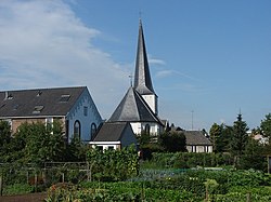
 Catholic St John church | |
| Coordinates: 51°59′17″N 6°34′11″E / 51.98806°N 6.56972°E | |
| Country | Netherlands |
| Province | Gelderland |
| Municipality | Oost Gelre |
| Area | |
| • Total | 11.49 km2 (4.44 sq mi) |
| Elevation | 21 m (69 ft) |
| Population (2021)[1] | |
| • Total | 12,910 |
| • Density | 1,100/km2 (2,900/sq mi) |
| Time zone | UTC+1 (CET) |
| • Summer (DST) | UTC+2 (CEST) |
| Postal code | 7131 & 7132[1] |
| Dialing code | 0544 |
Lichtenvoorde is a town in the east of the Netherlands, in the municipality of Oost Gelre.
Lichtenvoorde holds a flower parade (bloemencorso) every September at the start of its annual festival. The parade features floats covered in flowers (usually dahlias) in imaginative designs depicting a variety of themes.
Lichtenvoorde has a motorcross circuit on which international grands prix are held.
- ^ a b c "Kerncijfers wijken en buurten 2021". Central Bureau of Statistics. Retrieved 13 April 2022.
- ^ "Postcodetool for 7131AA". Actueel Hoogtebestand Nederland (in Dutch). Het Waterschapshuis. Retrieved 13 April 2022.
© MMXXIII Rich X Search. We shall prevail. All rights reserved. Rich X Search


