This article needs additional citations for verification. (June 2013) |
 | |
|---|---|
| Central Avenue (former) | |
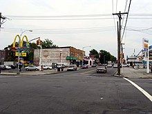
 Looking east at Springfield Boulevard in Cambria Heights | |
| Maintained by | NYCDOT and NCDPW |
| Length | 12.7 mi (20.4 km)[1][1][2] Combined length of three segments |
| Component highways | |
| Location | Brooklyn and Queens |
| West end | Flatbush Avenue in Flatbush |
| Major junctions | |
| East end | |

Linden Boulevard is a boulevard in New York City. Its western end is at Flatbush Avenue in Brooklyn, where Linden Boulevard travels as an eastbound-only street to Caton Avenue, where it becomes a two-way street. The boulevard stretches through both Brooklyn and Queens. This boulevard, especially the area of Cambria Heights between Springfield Boulevard and the Nassau County line represents a smaller version of shopping centers located on Jamaica Avenue and Queens Boulevard. Linden Boulevard also continues into Nassau County to Valley Stream where it turns into Central Avenue; this was one of several former names of the street in Queens.
- ^ a b Google (July 2, 2018). "Linden Boulevard" (Map). Google Maps. Google. Retrieved July 2, 2018.
- ^ Google (July 2, 2018). "Linden Boulevard" (Map). Google Maps. Google. Retrieved July 2, 2018.
© MMXXIII Rich X Search. We shall prevail. All rights reserved. Rich X Search
