List of islands of Tasmania

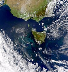
This true-color satellite image shows a large phytoplankton bloom, several hundred square kilometers in size, in the Indian Ocean off the west coast of Tasmania. In this scene, the rich concentration of microscopic marine plants gives the water a lighter, more turquoise appearance which helps to highlight the current patterns there. Notice the eddies, or vortices in the water, that can be seen in several places. It is possible that these eddies were formed by converging ocean currents flowing around Tasmania, or by fresh river runoff from the island, or both. Often, eddies in the sea serve as a means for stirring the water, thus providing nutrients that help support phytoplankton blooms, which in turn provide nutrition for other organisms. Effectively, these eddies help feed the sea (click to read an article on this topic). This image was acquired November 7, 2000, by the Sea-viewing Wide Field-of-view Sensor (SeaWiFS) flying aboard the Orbview-2 satellite. Tasmania is located off Australia's southeastern coast.
A satellite image of Tasmania while a phytoplankton bloom is of the west coast of Tasmania.

Tasmania is the smallest and southernmost state of Australia. The Tasmanian mainland itself is an island, with an area of 64,519 km2 (24,911 sq mi)[1] - 94.1% of the total land area of the state. There are more than 1000 smaller islands which have a combined area of 4,055 km2 (1,566 sq mi), making up the remaining 5.9% of total land area.[2][3]

  1. ^ "Land areas of States and Territories". Geoscience Australia. 1 January 2004. Retrieved 14 May 2021.
  2. ^ Cite error: The named reference brothers et al was invoked but never defined (see the help page).
  3. ^ "Islands". Geoscience Australia. Retrieved 14 May 2021.

© MMXXIII Rich X Search. We shall prevail. All rights reserved. Rich X Search