Back Малыя Карпаты Byelorussian Малыя Карпаты BE-X-OLD Малки Карпати Bulgarian Petits Carpats Catalan Malé Karpaty CEB Malé Karpaty Czech Kleine Karpaten German Malgrandaj Karpatoj Esperanto Pequeños Cárpatos Spanish Väikesed Karpaadid Estonian
| Little Carpathians | |
|---|---|
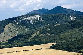
 Little Carpathians near Plavecké Podhradie | |
| Highest point | |
| Peak | Záruby |
| Elevation | 768 m (2,520 ft) |
| Coordinates | 48°31′25″N 17°23′33″E / 48.52361°N 17.39250°E |
| Geography | |
 Little Carpathians (shown in grey cross-hatching) within the geomorphological division of Slovakia
| |
| Countries | Slovakia and Austria |
| Range coordinates | 48°25′N 17°15′E / 48.417°N 17.250°E |
| Parent range | Western Carpathians |
The Little Carpathians (also: Lesser Carpathians, Slovak: Malé Karpaty; German: Kleine Karpaten; Hungarian: Kis-Kárpátok) are a low mountain range, about 100 km long, and part of the Carpathian Mountains. The mountains are situated in Western Slovakia, covering the area from Bratislava to Nové Mesto nad Váhom, and northeastern Austria, where a very small part called Hundsheimer Berge (or Hainburger Berge) is located south of the Devín Gate. The Little Carpathians are bordered by the Záhorie Lowland in the west and the Danubian Lowland in the east.
In 1976, the Little Carpathians were declared a protected area under the name Little Carpathians Protected Landscape Area, covering 646.1 km2 (249.5 sq mi). The area is rich in floral and faunal diversity and contains numerous castles, most notably the Bratislava Castle, and natural caves. Driny is the only cave open to the public. The three highest mountains are Záruby at 768 m (2,520 ft), Vysoká at 754 m (2,474 ft), and Vápenná at 752 m (2,467 ft).
© MMXXIII Rich X Search. We shall prevail. All rights reserved. Rich X Search