Back ليتل ديوميد (جزيره) ARZ Islla Diomedes Menor AST Kruzenştern Azerbaijani Little Diomede Island CEB Little Diomede Island German Diómedes Menor Spanish Little Diomede Estonian Pieni-Diomedes Finnish Lyts-Diomedes Frisian דיומיד הקטן HE
Native name: Iŋaliq (Inupiaq) | |
|---|---|
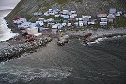
 The native Iñupiat village of Diomede/Iŋaliq on Little Diomede Island | |
| Geography | |
| Location | Bering Strait |
| Coordinates | 65°45′15″N 168°55′15″W / 65.75417°N 168.92083°W |
| Archipelago | Diomede Islands |
| Area | 2.43 sq mi (6.3 km2) |
| Highest elevation | 1,621 ft (494.1 m) |
| Administration | |
| Demographics | |
| Population | 77[1] (2023) |
| Pop. density | 33.72/sq mi (13.019/km2) |
| Ethnic groups | 96% Iŋaliq Iñupiaq[2] |
| Additional information | |
| Time zone | |
Little Diomede Island or Yesterday Island (Inupiaq: Iŋaliq, formerly known as Krusenstern Island,[a][3] Russian: остров Крузенштерна, romanized: ostrov Kruzenshterna) is an inhabited island, which is off of the coast of Alaska, and is a part of Alaska. It is the smaller of the two Diomede Islands located in the middle of the Bering Strait between the Alaskan mainland and Siberia. The island's one town is also called the town of Diomede.
Big Diomede Island, is located 2.33 miles (3.75 kilometers) to the West of Little Diomede Island and is a part of Russia. In addition to an international boundary, the International Date Line also separates the two islands.
As of 2021, the town of Diomede had a population of 82, down from its recorded peak of 208 in 1998.[1][4] All of the land of the Little Diomede Island is officially within the town of Diomede (named Iŋaliq as well).[2] The island is not part of any organized borough, so some services are provided directly by the state. For census purposes, it is included in the Nome Census Area.
During the Cold War, the section of the border between the U.S. and the USSR separating Big and Little Diomede became known as the "Ice Curtain". In August 1987, however, Lynne Cox swam from Little Diomede to Big Diomede (approx. 2.2 miles (3.5 km)) and was congratulated jointly by Mikhail Gorbachev and Ronald Reagan.[5]
- ^ a b "SUB-IP-EST2021-POP-02.xlsx". US Census Bureau. Retrieved December 29, 2022.
- ^ a b Local Economic Development Plan for Diomede, 2012–2017, citing 2010 U.S. census (and this was a decline since the 2000 census). Archived 2016-12-02 at the Wayback Machine.
- ^ "The American Local History Network". Archived from the original on April 24, 2012.
- ^ https://www2.census.gov/programs-surveys/popest/tables/1990-2000/cities/totals/su-99-7_ak.txt
- ^ "Lynne Cox swims into communist territory". History. Retrieved 7 August 2017.
Cite error: There are <ref group=lower-alpha> tags or {{efn}} templates on this page, but the references will not show without a {{reflist|group=lower-alpha}} template or {{notelist}} template (see the help page).
© MMXXIII Rich X Search. We shall prevail. All rights reserved. Rich X Search
