Back الزاب الصغير Arabic ܙܒܐ ARC Kiçik Zab Azerbaijani کیچیک زاب چایی AZB Малы Заб Byelorussian Малък Заб Bulgarian Zab Inferior Catalan زێی بچووک CKB Malý Záb Czech Kleiner Zab German
| Little Zab | |
|---|---|
 | |
 | |
| Location | |
| Country | Iran, Iraq |
| Region | Iraqi Kurdistan |
| District | Erbil Governorate |
| Municipality | Erbil |
| Physical characteristics | |
| Source | |
| • location | Zagros Mountains, Iran |
| • elevation | 3,000 m (9,800 ft)approx. |
| Mouth | |
• location | Tigris, Kirkuk Governorate, Iraq |
• coordinates | 35°14′17″N 43°26′11″E / 35.23806°N 43.43639°E |
| Length | 400 km (250 mi)approx. |
| Basin size | 22,000 km2 (8,500 sq mi)approx. |
| Discharge | |
| • average | 197.8 m3/s (6,990 cu ft/s) |
| • maximum | 3,420 m3/s (121,000 cu ft/s) |
| Basin features | |
| Tributaries | |
| • left | Baneh, Qala Chulan, Rubar-i-Basalam |
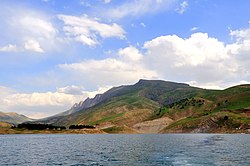
The Little Zab or Lower Zab (Arabic: الزاب الاسفل, al-Zāb al-Asfal; Kurdish: Zêy Koya or Zêyê Biçûk; Persian: زاب کوچک, Zâb-e Kuchak; Syriac: ܙܒܐ ܬܚܬܝܐ, Zāba Taḥtāya) is a river that originates in Iran and joins the Tigris just south of Al Zab in the Kurdistan region of Iraq. The Little Zab is approximately 400 kilometres (250 mi) long and drains an area of about 22,000 square kilometres (8,500 sq mi). The river is fed by rainfall and snowmelt, resulting in a peak discharge in the spring and low water in the summer and early fall. Two dams built on the Little Zab regulate the river flow, providing water for irrigation and generating hydroelectricity. The Zagros Mountains have been populated since at least the Lower Palaeolithic, but the earliest archaeological site in the Little Zab basin, Barda Balka, dates to the Middle Palaeolithic. Human occupation of the Little Zab basin has been attested for every period since then.
© MMXXIII Rich X Search. We shall prevail. All rights reserved. Rich X Search