Back Louisiade-Archipel ALS Archipiélagu de les Lluisiaes AST Луизиада Bulgarian Arxipèlag Louisiade Catalan Louisiade Archipelago CEB Louisiade-Archipel German Αρχιπέλαγος Λουιζιάντ Greek Ludovik-Insularo Esperanto Archipiélago de las Luisiadas Spanish Louisiade uharteak Basque
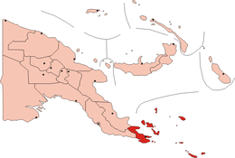
 Map of Papua New Guinea The Louisiade Archipelago is in the dark red area at the bottom of the map. | |
| Geography | |
|---|---|
| Coordinates | 11°12′S 153°00′E / 11.200°S 153.000°E |
| Total islands | 300+ |
| Area | 1,871.1 km2 (722.4 sq mi) |
| Administration | |
| Province | Milne Bay Province |
| Capital city | Bwagaoia |
| Largest settlement | Bwagaoia (pop. 2680) |
| Demographics | |
| Population | 47000 (2014) |


The Louisiade Archipelago is a string of ten larger volcanic islands frequently fringed by coral reefs, and 90 smaller coral islands in Papua New Guinea.
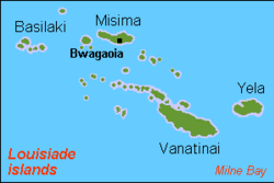
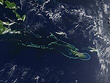
It is located 200 km southeast of New Guinea, stretching over more than 160 kilometres (99 mi) and spread over an ocean area of 26,000 square kilometres (10,000 sq mi) between the Solomon Sea to the north and the Coral Sea to the south. The aggregate land area of the islands is about 1,871 square kilometres (722 sq mi), with Vanatinai (Tagula) being the largest.
Rogeia, Samarai and Sariba lie closest to New Guinea, while Misima, Vanatinai, and Rossel islands lie further east.
© MMXXIII Rich X Search. We shall prevail. All rights reserved. Rich X Search